Genesis and paleoenvironmental significance of the Late Pleistocene buried paleosol in Hidalgo/Central Mexico
Otilio Acevedo Sandoval1, Misael Cruz Sánchez1, Sergey Sedov2
1 Centro de Ciencias de la Tierra, UAEH, México
2
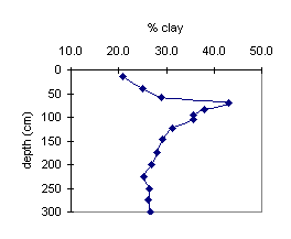
Instituto de Geología, UNAM, MéxicoThe territory of the Transmexican Volcanic Belt spreads over the southern part of the Hidalgo State, predetermining frequent occurrence of the Pleistocene volcanic sediments, often with buried paleosols. We discovered and studied a well preserved paleosol, covered by 10 m. of tephrous material in the outskirts of Pachuca, capital of Hidalgo state. The modern surface soil in this location is a Kastanozem with an Ah – Ck profile, corresponding to the present-day semiarid climate. In the extensive quarry exposure, the paleosol is sloping down following inclination of an ancient landsurface, that allows to study the profiles formed in different paleo-topographic positions. The paleosol located in the upper part of paleo-slope is a Luvisol with eluvial (E), clay illuvial (Bt) cemented carbonate (Ck) horizons. The Bk horizon is characterized by a well developed prismatic structure with illuvial clay coatings on ped surfaces and higher clay accumulation, compared to modern soil. We were surprised to find some areas, cemented with carbonates in the eluvial horizon. Their diagenetic origin is unlikely, because overlying sediments are free from carbonates. The radiocarbon date of the Ck carbonates is 23,320 +/-220 yr. B.P., and of E-horizon carbonates, – 23,150+/- 660 yr. B.P. We conclude that the paleosol was formed in late Pleistocene, in the first part of OIS2. The paleosol properties evidence that contrasting changes occurred during pedogenesis, from leaching, weathering and clay illuviation to recarbonization. We suppose that it reflects the evolution of paleoclimate from semihumid (probably, Mediterranean – type) to more arid.
Downslope this profile merges into pedocomplex, having 2 different paleosol members, separated by sharp boundary. The lower profile is a Luvisol, whereas the upper paleosol is less developed and has no signs of clay illuviation. Carbonate concretions are located in its lower part (near the sharp boundary with lower paleosol). We suppose, that the sedimentation, which caused the two-store composition of the pedocomplex and the formation of the upper, less developed paleosol, also corresponds to the late, more arid phase, marked in the upper paleosol by recarbonization of E horizon.
Palaeopedology of soils around Chennai, Tamil Nadu, India.
Hema Achyuthan
Centre for Geoscience and Engineering, Anna University, Chennai 600 025.
Soils around Chennai, Tamil Nadu are represented by ferricretes and red soils and these can be related to the underlying bedrock. In the present study, red soils and ferricretes have been studied from three different sites: Red hills, Vaipur and Pallavaram, which were formed over different parent rocks. Red soils and ferricretes around Vaipur and Red Hills are over the Upper Gondwana sandstone and shale while around Pallavaram; they are formed over the charnockites of the Precambrian age. In this paper micromorphology and geochemistry of ferricretes and red soils are presented.
Micro fabric elements in polished thin sections have provided a basis for the interpretation of processes involved in red soil and ferricrete formation. Micromorphology of red soils and ferricretes reveals high content of clay minerals and these are gibbsite, hematite, magnetite halloysite and smectite. Fe-oxide mineralogy is represented by hematite, gibbsite and magnetite. Pedogenesis has produced iron segregation that was formed into a great variability of colors, degree of opacification and both external and internal forms. Crack and fractures have been filled by iron oxide either by kaolinite or hematite. Some of the fractures are lined with black manganese oxide representing the final depositional phase. The complex process of groundwater fluctuation and pedogenesis has formed red soils and ferricretes of the study area. Based on geomorphology and occurrence of archaeological artifacts the soils were dated to Late Neogene-Early Quaternary period. Climatic conditions would have been wetter than today.
Analysis of botanical remains from excavations at Cuicuilco-Inbursa, Tlalpan, D.F.
Cristina Adriano Morán, Diana Martínez Yrizar, Mónica Moguel Bernal
Laboratorio de Paleoetnobotánica y paleoambiente, Instituto de Investigaciones Antropológicas, UNAM
A rescue excavation was undertaken in 1997 close to the construction site of the Cuicuilco-Inbursa tower near the archaeological site of Cuiculco. Sediment samples were taken from an area under the lava flow that now covers most of the site. Botanical remains recovered from the sediment, including plant macrofossils and pollen, were analyzed in order to determine the vegetation characteristic of the zone prior to the eruption of Xitle (ca. 500 BC).
Forty-nine samples were processed using flotation for the recovery of macrobotanical evidence and Hydrofluoric acid and potassium hydroxide extraction for the recovery of pollen. Identifications of plant remains the presence of genera pertaining to the arboreal (Pinus, Querqus) and herbaceous (Amaranthus, Chenopodium, Solanum, Verbena) strata as well as lacustrine association (Cyperus).
Transformation of soils of Moscow from Medieval to modern time as the result of cultural layer accumulation
E.I. Alexandrovskaya
Moscow Advanced Educational Inst., Starovatutinsky, 8, 129281 Moscow, Russia
In the central part of Moscow, above the surface of the initial soils (Albeluvisols, Podzols, Fluvisols), one can observe the cultural layer that was formed here in the 12-20th centuries. The thickness of this layer reaches 3 m on the elevated watersheds and up to 15 m in the depressions.
The accumulation of the cultural layer was a discontinuous process; often, active accumulation was interrupted. When the duration of these pauses in the sediment accumulation exceeded 10--20 years, thin (3-5 cm) soil humus horizons could develop under herbaceous vegetation and trees. Thicker soils (up to 20 cm of the humus layer) developed in the gardens.
The cultural layer contains mortar, bones and remains of timber debris, that is why it has an alkaline reaction and contains pedogenic carbonates, vivianite and organic matter. Carbonate has migrated into the underlying Podzoluvisol, and its reaction has changed from acidic to alkaline.
The horizons of the 17-19th centuries contain maximum concentration of such elements as lead, copper and arsenic (blue copperas that was used for pest control in gardens and orchards and in household). For example, arsenic in the horizons of the 18-19th centuries increases to 74 mg/kg (as compared to the background (clarke) value of 2 mg/kg). This increase resulted from the use of arsenic in the tanning and dyeing industries. These dies are bright and very stable; nowadays, their production is prohibited or severely restricted because of their harmful effect.
The content of pollutants at the depth of 1 m often exceeds the one in the surface layer. Deep layers with anomalously high concentrations of pollutants are extracted on the surface during excavation works, mix up with surface soils and enhance the degree of pollution of modern urban environment. The rise in the groundwater level has a destructive impact on the basement of buildings; this water gets saturated with various salts and toxic organic and inorganic compounds, which have a negative effect on green plantings and the biota as a whole.
Floodplain paleosols evolution in Holocene in Eastern Europe
Alexander Alexandrovskiy
Institute of Geography, Russian Academy of Sciences, Russia
The floodplains are characterised by high dynamics of all landscape elements, including soils. In the Holocene, the processes of river valley development, accumulation of alluvium, changes in flood levels and intensity resulted in periodical destruction and burying of older soils and development of new ones (Mandel, 1992).
In the floodplain of the middle Oka, some multilayered (from Neolithic to the Medieval period) settlements are found. Their cultural deposits are mostly correlative to buried soils (Alexandrovskiy et al., 1987). The soils were formed during the time when the plain was not flooded and the sedimentation of alluvium was interrupted. Four main buried soils dated by radiocarbon and archeological methods were identified from series of principal sections through the multilayered flood-plain settlements: S1 - Young alluvial soil of the floodplain, 300-100 BP; S2 - Early Iron age and Early Medieval cultural deposits, Luvisol, 2200-1000 BP; S3 - Bronze age, Fluvisol, 4000-2800 BP; S4 - Neolithic cultural deposit, Fluvisol, 6000-4500 BP.
When the Luvisol (S2) was formed, its profile developed downwards and illuvial Bt horizons were formed. The pedogenic processes reworked the underlying alluvial deposits, which caused their compaction and structural changes. The rates of alluvial accumulation calculated from the layer thickness and dating have considerably varied and notably lowered during the formation of the Luvisol (S2). The changes in hydrology of the floodplain led to multiple migrations of human settlements to the elevated positions and viceversa.
Because of progressive accumulation of alluvium many floodplains were not flooded any longer in the late and sometimes in the middle Holocene. As a consequence, soils of zonal types – Chernozems and Luvisols were formed on the floodplains. The periods of activation of alluvial sedimentation, which resulted in the burial of soils, are induced by climatic changes that occurred within the Holocene as well as increasing human impact. Deforestation and land cultivation in the river basins were enhanced in the last 700 – 900 years, causing an increase of intensity and level of floods. Because of this, on many floodplains of Central Russian Plain, Luvisols (Grey Forest Soils and Albeluvisols) were buried under recent alluvium, on top of which weakly developed Fluvisols are formed.
Paleoenvironmental changes on Bykovsky Peninsula (Northeastern Siberia) during the Late Pleistocene by pollen data and rizhopods.
A.A. Andreev1, A.A. Bobrov2
1Alfred-Wegener-Institut für Polar- und Meeresforschung, Telegrafenberg A43, 14473 Potsdam, Germany
2
Soil Department of Moscow State University, 119899, Moscow, RussiaPaleoenvironmental changes on Bykovsky Peninsula (Northeastern Siberia) â Late Pleistocene and Holocene were reconstructed by pollen data and rhizopods analysis.
The Testaceae amoeba communities with low species density, which characterized meso-oligotrophic (seldom for oligotrophic) with slightly acid soil environment are common for cold periods. The dominance of species from Centropyxis and Difflugia genera most likely reflects active process of redeposition and sedemintation of organic matter with enreached Ca2+.
In the contrary of the Late Pleistocene barried soils, hidrophilic species of Difflugia genus are more common in the Holocene sediments. These species are mostly obligate hidrobionts. The rhizopods biodiversity stands out in warmer periods.
The number of species in the samples, reflecting paleoenvironmental condition, is an important characteristic of paleocoenoses as well as species diversity, community structure, indicator species, and some other characteristis.
The outstanding richer diversity of Testaceae amoeba species compared with modern high Arctic soils is present in some periods of the Pleistocene and Holocene.
There were determinated the following periods:- 60,000 - 53,000 (cold and dry), 48,000- 42,500 (dry, but warmer than during previous period), 42,500 – 33,000 (dry and relatively warm), 28,000-28,500 (dry and cold), 26,000 – 16,000 (extremely dry and cold), 15,000-12,000 (amelioration of climate), 8200-4500 (warmest and wettest climate conditions), 4500-0 (modern climate). The main periods of climate changes, responsible for paleosols formation on the Bykovsky Peninsula for the last 60,000 yr BP were distinguished.
Characterization of Terra Rossas in the Bursa region of Turkey
Cumhur Aydinalp
Uludag University, Faculty of Agriculture, Department of Soil Science, 16059 Bursa / TURKEY
This study was undertaken as a preliminary investigation on the genesis of these soils in the Bursa region of Turkey. Terra Rossas occur in some parts of the region as isolated pockets. This soil type was formed on different parent materials under Mediterranean type of climate. These soils are under natural vegetation in the highest elevation of the region. The soils at the lower altitudes have been used traditionally on a variety of agronomic regimes such as cereals, vegetables, and orchards. At the Eastern side of the region, six soil profiles were selected for this research. The soils are formed on unconsolidated limestone and located at three different elevation. The physical, chemical, and morphological properties of the soils were examined and classified according to the systems of FAO/Unesco (1990), FitzPatrick (1988), and USDA Soil Taxonomy (1994). The objective of this study was to characterize six Terra Rossa profiles along an increasing vertical zonality, and to relate their properties to the pedogenic processes responsible for their formation.
The soils are shallow to deep, showing Ah-Bt horizons. They are alkaline in all profiles. Their texture varies from silty clay loam to clay. These soils show high clay content increasing with depth. The distribution of clay was increased gradually from the upper area to the lower one due to the geomorphological position of the profiles. The soils were allocated to the classes of Chromic Luvisols (FAO/Unesco, 1990), Argillos (FitzPatrick, 1988), and Typic Xeralfs (USDA Soil Taxonomy, 1994). The profile variation occurred according to their geomorphological location and pedogenetic process. Due to all results, it is concluded that the main process of soil formation is a periodic decalcification in these soils.
Genesis and Classification of Cambisols in Northwestern Turkey
Cumhur Aydinalp
Uludag University, Faculty of Agriculture, Department of Soil Science, 16059 Bursa / TURKEY
Cambisols occur in large areas of northwestern Turkey under natural vegetation. This soil group developed on various type of parent materials and geomorphic surfaces. This research was carried out as a preliminary investigation on the genesis of the most extensive soils under natural vegetation in northwestern Turkey. Six soil profiles were selected in this study. These soils are developed on schist parent material of Paleocene under dense cover which lies 200-450 m above sea level. Their characterization included field morphology, physico-chemical routine analysis and clay mineralogy.
The soils are shallow, showing Ah-Bw-C horizons. The texture of the soils varies from sandy clay loam to clay loam. Soil pH is slightly acidic in all the studied profiles. The obtained data indicate that analyzed soils were characterized by downward movement of clay, iron, formation of a cambic horizon and leaching of bases. According to the clay mineralogy, illite is the dominant mineral throughout all profiles. Kaolinite and chlorite-smectite are the minor minerals and gibbsite and plagioclases are present in trace amounts in all horizons of the profiles. All studied soils were classified as Eutric Cambisols (FAO/Unesco, 1990), Altosols (FitzPatrick, 1988), and Typic Xerochrepts (USDA Soil Taxonomy, 1994).
According to overall soil properties, it is concluded that at present the main process of soil formation is faunal mixing of organic and mineral material to form well structured fine granular upper horizons in the soils. Much of the variation among the soils can be related to the geomorphological position of the profiles and the geomorphological history of the region.
Magnetic Memory of Pedogenesis: Climatic and Microbial Proxies?
Subir K. Banerjee1, Rinita A. Dalan1, Eric A. Oches3 and William I. Woods4
1Institute for Rock Magnetism and Department of Geology and Geophysics, University of Minnesota, Minneapolis, MN 55455, USA
2
Department of Anthropology and Earth Science, Minnesota State,University Moorehead, MN 56563, USA3
Department of Geology, University of South Florida, Tampa, FL 33620, USA4
Department of Geography, Southern Illinois University Edwardsville, IL 62026, USAIt is well known that temperate region well-drained soils (~10ka old) and paleosols in the Chinese loess/paleosol sequences (0-2ma old) display so-called "standard" magnetic enhancement in susceptibility (
ξ) and anhysteretic remanent magnetization (ARM) as compared to the underlying less-altered loess. We present ongoing research in two frontier areas of soil magnetism: (a) The unexpected discovery of magnetically depleted paleosols in other loess/paleosol sequences and their paleoclimatic significance, and (b) Attempts to discover and estimate the role of iron-reducing bacteria (IRB) and/or anthropogenic factors in causing magnetic enhancement.For case (a), two hypotheses have been offered: (i) lower values of X in paleosols due to decreased delivery of lithogenic coarse magnetite during glacial climate as in Siberia and Alaska and (ii) lower values caused by oxidation of magnetite to hematite, as seen in loess of Buenos Aires province, Argentina. Through a multi-magnetic proxy approach, we show that even in Alaska neoformed magnetite is present and can provide information about paleohumidity and cyclic reductive/oxidative history. Iron diagenesis, and not fluctuating delivery of lithogenic coarse magnetite, may be the dominant control on magnetically depleted paleosols. For case (b), we provide examples of possible anthropogenic enhancement superimposed on natural enhancement at the Cahokia archaeological site in Illinois, at archaeological sites in the Red River Valley in Minnesota and North Dakota, and in Amazonian dark earths (terra preta do Índio). In addition, we describe results of controlled in vitro production of nanophase magnetite from iron hydroxide precursors by IRB. We hope that their magnetic signatures can thus help recognize and quantify past microbial activity. In short, careful multi-magnetic proxies and supporting soil morphological and chemical data can yield a comprehensive picture of past environmental conditions.
Biogenic silica of paleosols as indicators of past environments
A.A. Bobrov
119899, Department of Soil Science, Moscow State University, Vorob'evi Gori, Moscow, Russia
The morphological features of biogenic silica derived from plants and soil animals have been analysed. Biogenic silica of diatoms (Bacillariophyta), testate amoeba (Protozoa: Testacea), freshwater sponge (Spongia) etc is a basis of the systematics of these organisms (Round, 1973; Ogden, Hedley, 1980). The morphology of pancirery, shells and spinules is an important systematic criteria, since it is genetically determined (is controled by the genome). Morphological features of biogenic silica in lower plants and protozoa as well as the composition of their communities are also determined by the ecological conditions of their habitats. The well established systematics and ecology of silica-accumulating organisms are the basis for the development of such paleoecological methods as diatom analysis and rhyzopod analysis (Battarbee, 1986; Tolonen, 1986).
A possibility to use biogenic silica forms for paleoreconstuction of pedogenic factors has been supported by the example of burried soils of Dnepr river flood valley (archaeological complex “Gnezdovo”, Smolensk district, Russia). Sponge diatoms and spicules were also counted in 16 soil samples. The morphological diversity and amount of phytoliths have been determined as well as species composition and population density of shell amoebaes.
Several periods of alluvial soil development were recognised during the last two thousand years from the data on biogenic silica forms. The distribution of .diatoms and spicules along the soil profile was found to be similar. Decrease of diatom population density came together with the reduction of the amount of sponge spicules or their absense. Four periods of increasing hydromorphism appeared while diatom population density reached 100000 ind/g of dry soil.
As usual, an increase of the amount complied with appearence of phytoliths of hydrofilic plants - sedges and reed - in the soil samples. Pecularities of shell amoebae’s species composition made possible to specify the hydromorphic periods of soil formation.
Correlation of loess-paleosol sequences in East and central Asia with SE central Europe-towards a continental Quaternary pedostratigraphy ann paleoclimatic history
Arnt Bronger
Geograph. Institut Universität Kiel, D-24098 Kiel, Germany
Recent small climatic fluctuations on a 102-103 year time scale can be correlated worldwide e.g. by distinct moraines dated to about 1850 D in similar positions below the present day glaciers in the southeastern Canadian Rockies, in the European Alpes and in the Tian-Shan near Urumqi, China. These moraines result from glacier advances caused by a decline of a mean annual temperature of only
1°C. This suggest that major climatic changes on at least a 105 year scale (glacial-interglacial cycles) and probably 104 year scale (the appropriate length of an interglacial) must be of similar ages throughout the temperature climatic belt of the Northern hemisphere. This concept allows continental pedostratigraphical correlation. Detailed knowledge of the genesis of paleosols is needed to establish loess-paleosol stratigraphies that can be used for paleoclimatic reconstruction. However, most paleosols are truncated and largely recalcified from overlying loess. Micromorphological studies allow primary and secondary carbonates to be distinguished and provide unequivocal evidence of clay illuviation. This enables the separation of typical loess, weathered loess and recognition of different genetic soil horizons as CB, BC, Ah, Bw and Bt horizons. For the Brunhes epoch, the sequence at Karamaydan, Tadjikistan is more detailed than the corresponding section in Luochuan, China and even more than in SE Central Europe except for the last glaciation. The very good correlation with the deep-sea oxygen isotope record of Bassinot et al. (1994) which includes the development of an accurate astronomical time scale, allows a detailed cronostratigraphical subdivision of the loess-paleosol sequence at Karamaydan. Therefore, this sequence should be regarded as a key sequence for reconstructing the climatic history of the Brunhes epoch. This conclusion implies that the loess-paleosol sequences in SE Central Europe are more incomplete than what was thought earlier. Pedocomplexes in Karamaydan correspond with single paleosols in SE Central Europe, e.g. the F6 paleosol in Stari Slankamen with pedocomplexes PKVI and V at Karamaydan, which were formed over a period of about 140 ka, although pedogenesis was interrupted several times by loess deposition. Therefore, the F6 is an example of a welded paleosol as the F5, F4 and F2 paleosols. For most of the Matuyama epoch, the central and lower parts of the sequence at Chashmanigar show more pronounced paleosols than the equivalent parts at Luochuan; in the SE Central Europe only in the Stari Slankamen three strongly developed but truncated paleosols F9-F11, above neogene sediments are exposed. Mineralogical investigations of the silt and clay subfractions show that there is little difference in the type and amount of pedogenic clay mineral formation between the Holocene soils and the paleosols of the Brunhes epoch at Karamaydan and of the paleosols in the Matuyama epoch at Chasnabigar. This suggest that the interglacial climates represented by the B or Bt horizons of the buried paleosols of the young, middle and old Pleistocene age were similar to that of the Holocene.
Application of ground penetrating radar to paleopedological prospecting in volcanic zones: a study case in the Chalco basin
Dora Carreón-Freyre
Unidad de Ciencias de la Tierra (UNICIT), Instituto de Geología, UNAM, Querétaro, México. freyre@servidor.unam.mx
Ground Penetrating Radar (GPR) profiles, or radargrams, were collected in the lacustrine deposits of Chalco, in Mexico, with a ZOND 12c equipment (Radar Systems, Inc.) using the 900 and 300 MHz antennas. The aim of this work was to assess the application of this non-destructive tool to the identification of paleosols in volcanic-lacustrine basin sequences.
At GPR frequencies, the dielectric constant variations of soils and granular materials are related to specific interactions between the electromagnetic waves and water molecules filling voids. Therefore, water content, physico-chemical characteristics of pore water; solid-liquid-air proportion and, soil structure control radar wave behavior and are related with physical aspects of soils and sedimentary materials. As a matter of fact, the GPR method has a low detection capacity in saturated clayey materials due mainly to their high water retention capacity and low electrical resistivity. However, when a high dielectric contrast is present, for example between clay and sandy materials, the capacity of detection improves considerably with increasing salinity of pore water and textural contrasts.
The Chalco sequence is characterized by soils and saturated layers of plastic clay (with saline pore water) alternating with volcanic ashes and pyroclastic sand. In order to quantify physical variations that can produce electric contrast to be recorded in a radargram, core samples of the Chalco site were analyzed at the Geomechanical Laboratory of the UNICIT (UNAM). In the field, parallel vertical GPR profiles were obtained in two perpendicular directions in order to identify the spatial variations of the recorded reflectors. The surveying was based on detailed observations of the physical variations of the soil profiles. Analysis of radargrams supported by punctual determinations of water content, electrical conductivity, granular size and, textural changes demonstrated a relation between the electromagnetic recorded response and the physical properties of the clayey-sandy lacustrine sequence.
Results presented show the stratigraphic, textural and structural features recognized in the radargrams. The best definition in the stratigraphical and structural features was obtained with the 300 MHz antenna, whereas soil characteristics were best recorded using the 900 MHz antenna. Two of the principal stratigraphic targets with contrasting electrical properties were a paleosol located between 0.45 and 0.80 m depths and a sand layer located between 2.55 and 2.85 m depths. The structural and textural heterogeneities such as fractures, sand lenses, and concretions within a brownish silty clay at 1.3 m depth presented a specific radar signature.
We can state that comparisons of profiles from a lacustrine sequence permitted lateral and vertical stratigraphic monitoring of paleosols and permit a field characterization of the soil morphology and depositional conditions of sedimentary materials.
Clay minerals and pedogesis of quaternary soils of the Montagnola Senese (central Italy)
Edoardo A.C.Costantini1, Damiano Damiani2
(1) Istituto Sperimentale per lo Studio e la Difesa del Suolo, Mi.P.A., P.za M. D’Azeglio, 30, 50121 Firenze
(2)
Dipart. Scienze della Terra Univ. di Siena, Laterino, SienaClay mineral analysis can improve the comprehension of soil forming processes. By means of this kind of analysis it is possible to characterize soil parent material and relate it to the bedrock, but also to connect mineralogical transformation with soil-forming processes. Clay mineral analysis has been utilized in the study of recent soils and paleosols of the Montagnola Senese, in Central Italy, which had already been investigated to evaluate soil geochemistry and the relationships between Quaternary geomorphological evolution and the occurrence of fragipan and other close-packed horizons.
The twelve soils studied developed on acid rocks and on slope, alluvial and colluvial deposits, were dated in a time span ranging from Lower Pleistocene to Holocene.
Illite and kaolinite were found to be the most quantitatively important phyllosilicate, while vermiculite, hydroxy interlayered vermiculite (HIV), illite-HIV and illite-chlorite mixed layers, and chlorite content were related to different degrees of soil weathering. Comparing soils of different ages, the most characteristic clay mineralogy transformation with time was a progressive increase of kaolinite and vermiculite, as well as a decrease of illite.
The most outstanding pedological processes, i.e. crystalline free iron content, clay illuviation, glossic horizon and fragipan formation, were all found to be related to kaolinite content.
Clay mineralogy examination of the soil horizons also permitted a differentiation of so-called “lithological discontinuities”, which had been recognized during the field survey, into lithological and chronological discontinuities of the soil profiles.
Pedosediments –significance for reconstruction of the Middle Pleistocene paleosol genesis in loess-soil series (East European Plain, Russia)
K.G. Dlussky
Institute of Geography, Russian Academy of Sciences, Staromonetny, 29, Moscow, 109017, Russia, paleo@online.ru
The central East European Plain is the northest region of the World with Middle Pleistocene paleosols preserved up to now. Those occur in the loess-soil-cryogenic series below the Dnieper (Saale, stage 6) loess overlain by the Mezin soils complex (Eemian, stage 5e). In the region, two interglacial soils developed between the Dnieper and Oka glaciations under conditions of boreal and subboreal climate are known as Upper Kamenka and Inzhavino (or Lower Kamenka) soils. The soils are dated to the interval 250 to 450 ka BP.
The paleosols have been repeatedly eroded over the territory and can be found at the present time but just in a few sections. Those sections have been studied by using a range of techniques. Carbonates, organic matter, micromorphology, R2O3 and clay differentiation along the soils profile were observed. It seems, that the lower paleosol (Inzhavino) is present in several sections as pedosediment.
Its stratigraphic position is defined as occurring between the Upper Kamenka soil and deposits dated to the Oka glacial epoch. Such a case is of special interest, because it provides a possibility to appraise the pedosediments as a source of data on the soil formation, during the ancient warm stages. In the reconstructions, it was assumed that the paleosol properties, as recorded in the fossil soil profile, reflect primarily climate and environment of the optimum interglacial.
Pedosediments occur generally in small paleo-depressions or on paleo-slopes. At present, those landforms are buried, and only a portion of paleo-catena can be seen in the exposures. Therefore, it had to be also assumed that any given pedosediment contained the material derived from a single paleosol and was removed only from the eluvial part of the mentioned landscape. To make a conclusion as to the provenance of the pedosediment material, the organic matter composition and properties were studied together with a micromorphological analysis.
When analyzing specific properties of organic matter, only conservative characteristics were used, such as humus group composition, humic acids to fulvoacids ratio, humification degree (Cha/Ctot) and optical properties of humic acids. Where possible, the most humified layers were sampled and analyzed. The analyses have shown that in case two nearby sections were studied, one with the Inzhavino paleosol, and the other with a stratigraphically analogous pedosediment, the organic matter of the two formation is similar. In the micromorphological studies of the pedosediments, our primary attention was paid to the nature of microaggregates, composition and structure of the clay coatings, and to b-fabric types. There are also iron and carbonate neoformations.
It has been shown that aggregates from illuvial horizons are well-preserved in pedosediments; they include clay coatings as papules and fragments of channel-like voids. There are characteristic deformations of microaggregates that resulted from redeposition. The presence of speckled and striated b-fabric types, suggests that argillification in situ, is present in the original paleosol formation.
As an example, a number of sections from the Oka drainage basin are considered; the Inzhavino paleosol features, an eluvial-illuvial profile there and developed with participation of surficial gleying processes.
Late Pleistocene Fragipans and Duripands in Morelos State, México: paleopedological and paleoenvironmental aspects.
David Flores-Román1, Jorge Gama-Castro1, Elizabeth Solleiro-Rebolledo1, Sergey Sedov1 Guadalupe Escamilla2 and Douglas Donahue3
1Departamento de Edafología, Institututo de Geología, UNAM, Mexico
2
Posgrado en Ciencias de la Tierra, UNAM, México3
Physics Department, University of Arizona, Tucson, AZ, the USASubsoil indurated horizons (fragipans and duripans) known under the local name "tepetates" are spread throughout the Transmexican volcanic Belt. Numerous earlier works on tepetates were mostly dedicated to mechanisms and agents of induration. Our research on tepetates of Morelos State focuses on timing of tepetate formation and its interrelation with (paleo)pedogenesis and sedimentation in vertical profiles and toposequences in the course of environmental change– the problems still not studied extensively.
Soils, formed on the Holocene volcanic sediments under present day humid climate are Andosols or Cambisols, having high proportion of amorphous components in fine material. Tepetates are in all cases associated with thick polygenetic, often welded Luvisols, developed on older landsurfaces. It was noticed that on the long uniform slopes (glacis) covered with Luvisols, Tepetates appear in the middle- and lower part of the slope. The AMS dating of the carbon, occluded in Fe/Mn concretions of the buried Luvisol E-horizon in the key site of Buenavista and further stratigraphic correlation showed that the tepetates were formed in the Late Pleistocene (before ~12,000 yr. B.P.). 1:1 clays (mainly halloysite) are the main cementing agent of Tepetates and main component of fine material in associated Luvisol Bt horizons.
The origin of clay in subsoil indurated horizons could be related to 2 processes: 1) slow illuviation (in solutions with subsequent synthesis, partly – in suspensions) from overlying Bt horizons, where a lot of Si and Al are liberated due to weathering. 2) incorporation of clay-rich Bt material in the mixed volcanogenic-colluvial sediments, formed rapidly during the phases of high volcanic activity. Both processes were confirmed by micromorphological observation and can contribute in different proportion to tepetate formation.
The contrasting differences in the clay composition of modern soils and older Luvisols was primarily explained by differences in the duration of pedogenesis under similar humid climatic conditions. Recent alternative interpretation suppose that more contrasting seasonal variations of precipitation or short-term dry phases in the late Pleistocene supported the formation of 1:1 clay minerals more than amorphous components and thus stimulated the development of Luvisols and Tepetates. This hypothesis agrees better with the Late Quaternary paleopedological and lacustrine records of Central Mexico as well as the data from clima- and chronosequences of the surface volcanic soils.
Model of spatial distribution of volcanic-paleosols of central Transmexican Volcanic Belt, Mexico: a regional approximation
J.E. Gama-Castro1, E. Solleiro-Rebolledo1, Sergey Sedov1, C. Jasso-Castañeda2, G. Escamilla-Sarabia2 and E. Andrade-Ibarra3
1Instituto de Geología, UNAM, México
2
Posgrado en Ciencias de la Tierra, UNAM, México3
Intituto de Física, UNAM, MéxicoPaleosol-sedimentary sequences of Central Mexico, provide a unique paleopedological record of Late Pleistocene-Holocene climates of tropical Mesoamerica. However, despite recent progress, many questions remain unresolved, especially those related to the patterns of the paleosol spatial distribution and variability within this geographical area. The reasons why we studied such distribution and variability include the following: (a) to quantify pedogenesis as related to soil-forming factors and processes; (b) to determine optimum allocation of sampling units for the most efficient statical design and (c) to determine spatial variability of paleosols in three dimensions so pedogenesis and soil behavior can be easily visualized.
In this paper, an overview of the current state of knowledge of the paleosol distribution in the physiographic province of Central Transmexican Volcanic Belt (TMVB) is presented. The available data show the age of these paleosols as Late Pleistocene and Holocene. Their spatial distribution is described and, in particular, reference is made about the relationship between paleosol parent material, climate, landforms and surface morphometry in the TMVB. The description of extrinsic and intrinsic characteristics demonstrates the influences of regional factors in the distribution. The prominent influence of these regional factors, that also affected the genesis, evolution and mineral composition of the paleosol sequences, is emphasized.
Satellite image interpretation and field studies related to the geomorphic components and soils of Central TMVB, have shown that the paleosol distribution is closely parallel to that of Late Pleistocene-Holocene active or extinct volcanoes and some volcanic and periglacial landforms in this area. So, we consider that the distribution of Quaternary volcanic paleosols in TMVB; including: "Andic", "Cambic" and "Luvic kinds, as well as their intergrades (spatial variability), are geographically predictable. Finally, field research results strongly indicate, that Luvic paleosols (Luvisols) may represent the original floor of Late Pleistocene in Central TMVB.
Human palaeoimpact and soil evolution at the central part of Russian Plane (based on the biomorph analysis)
Alexandra Golyeva
Institute of geography RAS, Moscaw, Russia
The whole Russian Plain was inhabited by man in the second part of the Holocene. Because of that, the imprints of human activity can be found in the Holocene soils (including buried paleosols) in all landscape zones. In some cases, the soil features produced by human activity can be mistaken for climatic signals that cause interpretation problems. We studied the soils in the vicinities of ancient settlements and sequences of buried paleosols at small valleys (balkas) in humid and semihumid zones of Russian Plain, to determine the type and degree of anthropogenic environmental change and its influence on further soil evolution.
Radiocarbon dating and traditional soil analyses were used. The main method was biomorphical. The biomorph analysis is the study of the macro and micro remains of biota (biomorphs), in the context of the conditions of their origin. Each of the biomorphs (phytoliths, pollen, diatoms, sponge spicules and others) characterizes the specific conditions of the origin and evolution of a soil profile. Multiple biomorph analysis that includes the study of as many different biomorphs as possible allow to obtain additional information on the genesis and evolution of a soil. Data on these studies complement each other; their integrated analyses make it possible to reveal an unambiguous picture of the event sequence in the development of a particular soil object. The application of biomorph analysis permit to: (a) distinguish the origin of some soil-forming rocks, especially those of hydromorphic nature; (b) identify such events as erosion and accumulation and to judge the thickness of eroded or deposited layers; (c) diagnose the anthropogenic impacts on soils, even when there are no evident morphological traces of these impacts; (d) reveal the composition of local and regional plant communities; (f) identify and diagnose the buried character of soil horizons. By using biomorph analysis, it is possible to obtain new, previously unavailable information and to elucidate some controversial questions on soil genesis and evolution. All these adventages of biomorph analysis lead us to consider this method very promising in the study of soil and to recommend it for wider application during the study of soils, natural and anthropogenic deposits.
Our results have shown considerable human impact on surrounding landscapes and soils in all studied sites. In humid zone the soils on the sandy parent material were studied near the bronze age settlement in Ryazan oblast. Forest cleaning which caused the formation of humus-rich neutral meadow soil was documented. About 500 ye. after the settlement was abandoned, the zonal type of vegetation – pine forest – was restored in the area. The upper part of the profile was transformed in the Podzol direction, whereas the lower part of the meadow soil humus horizon persisted at 35-45 cm, forming the so called “second humus horizon”.
Sequences of buried soils in balkas near ancient settlements in a semihumid zone (Tula oblast), also indicate man-induced deforestation. Forest cleaning and subsequent cultivation caused strong erosion, resulting in the burial of soils in balkas under colluvium, derived from humus horizons of the watersheds. When land –settlements- was under no activity havin low human impact, colluviation ceased, forests were restored and soil formation features, typical for forest pedogenesis, proceeded.
We conclude, that in the second part of the Holocene human activity was one of the main factors of soil evolution. At least in the areas around the settlements, its influence was more pronounced than global climatic change.
Paleosols and volcanic sequences in Nicaragua
Pavel Havlíček
Český geologický ústav, Klárov 3, 118 21 Praha 1
The micromorphological soil studies and the Quaternary-geological field investigations carried out between the years 1997 and 2000 established the existence of a whole cratena of fossil and subfossil soils, which starts with syrosems (raw soils) and rankers and ends with earthified rotlehms (red plastosols, ultisols). The best developed and most intensive soils occur upon the pumice and andesite substratum, whereas those upon volcanic cinders and tuffs are less expressive. The same is true for non-volcanic sediments, like for example sub-fossil soils within the fluvial overbank deposits.
Marshy soils and equivalent redeposited soil sediments are present in the mangrove strips along the Pacific coast (e.g. in the vicinity of Leon town and the Cosiquina volcano). Frequent admixture of fresh unweathered volcanic material indicates frequent repetitions of intensive volcanic activities. The proximity of an active volcano is indicated by the presence of volcanic edaphoids, originated from pumices of volcanothermic processes. The identified soil types developed upon the volcanic rocks -volcanic ashes, tuffs, cinders and pumices correspond to Andosols (cf. Soil Taxonomy, 1975). The individual identified soils differ strongly and, therefore, also the relevant time interval needed for their development is different. While the raw soils and rankers developed a relatively short time (approx. decades) the development of plastosols lasted probably for thousands of years or more. Of course more exact time estimations are not possible due to the lack of concrete data.
Paleopedological Evidence of Human-Induced Environmental Change in the Puebla-Tlaxcala Area During the Last 3,500 Years
Klaus Heine
University of Regensburg
In the basin of Puebla-Tlaxcala in central Mexico, there has been a pronounced relationship between climate change, geomorphology and soil erosion on the one hand and the development of the ancient civilisations on the other hand (HEINE 1978, 1983, 1988; COOK 1986). There is no direct relationship between climate and the development of civilisation. Changes in settlement patterns and other human activities (land-use) have been influenced mostly by human, not natural factors. Soil erosion in the Puebla-Tlaxcala basin has been almost exclusively a result of human activity. Various phases of increased soil erosion occurred during times of population growth, increased settlement of previously uninhabited upper slopes of the volcanoes as well as intensification of agriculture. As early as 2000 years ago during the Tezoquipan phase, large areas had been eroded all the way to resistant indurated horizons (tepetate and caliche). Geomorphologic, sedimentologic and paleopedologic evidence shows that 2000 years ago, larger areas of central Mexico were devastated by erosion than at present. During the Tenanyecac phase (AD 100 - 650), isolated farms were abandoned in favour of villages. While villages increased in size, there was an overall decrease in population. Areas with pronounced soil erosion experienced especially large decreases in population. It appears that people moved to the villages. In comparison the number and location of villages in the basins, where soil erosion was not widespread, has remained relatively constant since about 600 B.C. After the Tenanyecac phase, population increased during the Texcalac phase, resulting in renewed cultivation of slopes prone to erosion. When population decreased during the following Tlaxcala phase, soil erosion also became less pronounced. After the conquest of Mexico by Spaniards in AD 1521, disease caused significant reduction in population over a short period of time. Simultaneously, erosion decreased because large areas of arable land were not cultivated. Since then, erosion has increased, especially after AD 1900.
It appears that cyclical political developments (cf. MARCUS 1992) are responsible for a large part of the observed cycles of soil erosion: The phase of reduced soil erosion between AD 100 - 650 (cf. FOWLER 1987) coincides with a decrease in influence of Teotihuacán on neighbouring regions. At the same time Teotihuacán itself experienced the highest population density of its history. Considering this evidence, it is no surprise that phases of soil erosion in central Mexico are asynchronous both in time and space.
References
Cook, A.G. (1986): El control de la erosión en Tlaxcala: Un problema secular. - Erdkunde 40: 251-262.
Fowler, M.L. (1987): Early Water Management at Amalucan, State of Puebla, Mexico. - Nat. Geogr. Res. 3: 52-68.
Heine, K. (1978): Mensch und geomorphodynamische Prozesse in Raum und Zeit im randtropischen Hochbecken von Puebla/Tlaxcala, Mexiko. 41. dt. Geogr.-Tag Mainz, Tagungsber. u. wiss. Abh., Wiesbaden: 390-406.
Heine, K. (1983): Bodenabtrag in Zentralmexiko: Messungen - Extrapolationen - geomorphologisch-sedimentologische Befunde. - Geogr. Ztschr. 71: 28-40.
Heine, K. (1988): Klimagang, Geomorphodynamik und Kulturentwicklung in Zentralmexiko. - Jb. Geogr. Ges. Hannover 1988: 189-211.
Marcus, J. (1992): Political Fluctuations in Mesoamerica. Dynamic Cycles of Mesoamerican States. - Nat. Geogr. Res. & Expl. 8: 392-411.
Characteristics of some paleosols formed on the Ganges floodplain in Bangladesh
M.S. Hussain, S. Ferdous and M.M. Rahman
Department of Soil, Water & Environment, University of Dhaka, Dhaka-1000, Bangladesh
The Gangetic flood plain in Bangladesh covers an area of 3 million hectares of the Bengal delta. The sediment of this floodplain has around 40 percent weatherable minerals. From the estimated 2.5 billion tons of sediments carried out to Bangladesh by the rivers a portion is deposited on the various floodplains during the monsoon season facilitating the formation of Paleosols in some selected locations. Results of six soil series from the Gangetie flood plain having buried soils in their profiles are reported in this paper. These soils are seasonally flooded and remain inundated for different periods.
Morphologically, the paleosols are identified by the presence of relatively darker horizons than those occurring above them in the profile. Therefore, color is an important indicator for paleosol identification. The organic matter in the surface horizon is high, but it is higher in some subsoil horizons. Texture of the surface soil varies from silty clay loam to clay. Paleosol particle size distribution shows an abrupt variation in some profiles while in some others, it is uniform. The present clay contents show a variation from 31 to 81%. The pH values in the surface horizons are higher and range from 5.2 to 7.8. The cation exchange capacities of soils range from 13.1 to 47.6 cmol/kg. Clay mineralogy is dominated by 2:1 expanding lattice minerals followed by mica and kaolinite. These soils have been classified as Thapto-Histic Haplaquepts. Rice is the major crop in all these soils yielding two tons per hectare.
Why bauxites were formed during the Paleogene in Siberia?
Alina I. IAKOVLEVA
Departamento de Paleontología, Instituto de Geología, UNAM; México
The presence of the Paleogene bauxites in the Yenisey River Basin (Siberia), which is characterized at the present time by the cold-temperate climate, is obviously linked to the fact that during the last 65 Ma the paleogeography of Eurasia and, in consequence Earth’s climate system, has experienced continuous change. On the basis of dinoflagellate cyst analyses, four new paleogeographical reconstructions are proposed for the late Paleocene- early Eocene of Western Siberia. The maximum flooding of Siberian Sea connected to the Arctic Basin and the Tethys corresponds to the latest Thanetian-Ypresian. It is suggested that the first major regression of Siberian Sea from the north due to the separation from the Arctic Basin occurred during the Lutetian. The last marine regression occurred at the end of Eocene: from the Oligocene no communication existed between the Arctic Basin and the Tethys via Siberian Sea and Turgay Strait. At the same time the palynological data suggest that the climate of Western Siberia was close to subtropical with dominance of evergreen taxa during the late Paleocene-early Eocene; towards to the end of Eocene the climate became progressively colder. The time of this cooling corresponds to the complete disappearance of Siberian Sea. The impact of important paleogeographical changes such as disappearance of Siberian Sea and Turgay Strait on the climate, biodiversity and pedogenesis of Eurasia during the Cenozoic is discussed.
Paleosols of the Continental Border of NE Buenos Aires Province. Argentina
Perla A.Imbellone and Andrea Cumba
Instituto de Geomorfología y Suelos. Universidad Nacional de La Plata. Calle 3 n 584. 1900.La Plata. Argentina. Tel/Fax: 54-0221-422-9923. E.mails:
imbellon@netverk.com.ar; andrea_c@netverk.com.arThe sediments with loessic characteristics of the pampean plain are called “loess y limos pampeanos” (pampean loess and silts) (Frenguelli, 1955) to separate those of purely eolian origin from the reworked by water. The term “loessoide” (loess like) is used by the same author to designate the second ones.
In the continental border of La Plata River, mainly loess-like sediments of the Late and Middle Pleistocene outcrop at approximately 20 Km from the coast. In the same direction they underlie at 2–5 m depth to the Holocene sediments (Imbellone, 1996) deposited by the regressive events in the successive lowering of sea level during the latest 6.000 years. At Parana River bluffs loess like sediments are exposed.
The object of this work is to describe the field, sedimentological and mineralogical characteristics, as well as the intensity of the paleopedogenic processes in the area. To integrate previous and new information, four big quarries with loess-like sediments are described laterally.
Successions are at about 15 m.a.s.l. with partially continuous development of pedological features from the macroscopic point of view. The buried paleosols are superposed, welded with different pedogenesis degree, indicated by macro and micromorphological features of illuviation and hydromorphism. In some cases these features would have been formed simultaneously with the deposition of the aeolian dust trapped by grass vegetation and reworked by water. The pedogenesis degree would depend on the relationship between the intensity of the accretion and reworked process and pedogenesis. Pedogenesis affected partially or totally the sedimentary units.
Two units of rich volcanic glass loess-like deposits were detected at San Pedro quarry (Cumba and imbellone, 1999). Previous (Riggi et al, 1986; Teruggi e Imbellone, 1988) and new information reveals the same situation near La Plata city. The upper one is found between 2 and 3 m deep, with 20 to 30% of volcanic glass and in cases constitute the parent material of the present soil. The deeper unit is at 7 –10 m depth, with 60 to 70% volcanic glass. Micromorphological observations confirm the presence of scarce to abundant clasts of previous illuvial horizons and loess embedded in the majority of sediment matrix.
Pedological processes are more developed at the deeper part of the successions indicated by strong structure degree and abundant, laminated and complex textural and amorphous features. The loess-like units and the associate lower paleosols could be informal stratigraphic correlation units for the continental deposits of the area.
References
Cumba, A. and P.A. Imbellone, P. 1999. Indices pedoestratigráficos en sucesiones costeras de la zona de San Pedro. Provincia de Buenos Aires. 245-249. 5ª Jornadas Geológicas Bonaerenses. Mar del Plata. Argentina.
Frenguelli, J. 1955. Loess y limos pampeanos. Serie técnica y didáctica Nº 7. Universidad Nacional de La Plata. 88p.
Imbellone, P.A. 1996. Redistribución de carbonato de calcio en sucesiones cuaternarias de la llanura costera bonaerense. A.A.S.Revista 3: 63-76.
Riggi, J.C., F.Francisco, O.R.Martínez and N.Porro. 1986. Geología de los “Sedimentos pampeanos” en el Partido de La Plata. Asociación Geológica Argentina, Revista XLI: 316-333.
Teruggi, M.E. and P.A. Imbellone. 1988. Paleosuelos loéssicos superpuestos en el Pleistoceno superior- Holoceno de la región de La Plata. Ciencia del Suelo 5: 175-188.
The parent material as the dominant factor on the hypsithermal pedogenesis in the Uruguay Basin (NE Argentina, SW Brazil, W Uruguay)
Martin Iriondo and Daniela M. Kröhling
CONICET – Facultad de Ing. y Ciencias Hídricas, UNL; C.C. 217 (3000) Santa Fe, Argentina
In the Uruguay river basin (285,000 km²) a generalized pedogenesis occurred during the Climatic Optimum of the Holocene, approximately between 8,500 and 3,500 years before Present. This period of 5,000 years was characterized by a humid and warm climate.
In terms of factors of soil formation an interesting pattern appears. The climate was relatively homogeneous on the whole basin. The age is the same in all cases and the influence of relief and vegetation was modest. Therefore those factors can be considered as basically uniform. On the contrary, the parent materials form a complex mosaic. The granulometric and mineralogical characteristics of the parent materials dominate the nature of the hypsithermal pedogenesis even at the higher level of the soil classification.
Several cases of this regional pattern can be cited. Moderately to well developed B horizons of six buried soils have been registered in the region. Each of them cover a significant area.
A buried soil belonging to the Ultisol Order was developed on the Oberá Formation (the Late Pleistocene tropical loess) in the north of the region (in Misiones province, Argentina; and Rio Grande do Sul state, Brazil). A well developed Argillisol –Alfisol- was generated on the lower fluvial terrace of the Uruguay (the Concordia Formation, Lower Holocene in age) and tributaries in the middle-lower basin (in E Corrientes and W Entre Ríos provinces, Argentina; SW Rio Grande do Sul state and W Uruguay). Some profiles are pedocomplexes with clear evidence that the soil formation was interrupted by the accumulation of andean volcanic ashes.
On a Late Pleistocene-Lower Holocene paludal unit (the Tapebicuá Formation, in E Corrientes province) a distinct buried soil with an argillic yellowish brown horizon was developed. A moderately developed Gleysol appears on the lower terrace of the tributaries in SW Rio Grande do Sul state (the Touro Passo Formation, Lower Holocene in age). A conspicuous Vertisol covers the southwestern of the river basin (in Entre Ríos province). The parent material of this buried soil is a clayey playa unit (Hernandarias Formation, Lower Pleistocene in age).
On the Late Pleistocene loess at the exteme south of the basin (in SE Entre Ríos province and W Uruguay), appears a moderately developed Argillisol, which is the typical occurrence in the Pampa region.
The hypsithermal soil was truncated by aeolian erosion in most of the region. Later, it was covered by a thin loessic layer (the San Guillermo Formation, sedimented during the Upper Holocene). Both, the remaining B- and C horizons and the loess layer, are affected by the current incipient pedogenesis under a humid subtropical/tropical climate, which began 200 years ago. The only exception to this influence is represented by the Ultisol, which is covered by 2 – 4 m of red fine aeolian sediments (Upper Holocene in age), and consequently isolated from the present dynamic.
Holocene soil stratigraphy of Central Nebraska: Aggradation of the loess tablelands
Peter M. Jacobs1 and Joseph A. Mason2
1Department of Geography and Geology, University of Wisconsin-Whitewater
2
Conservation and Survey Division, University of Nebraska, Lincoln.In central Nebraska, Holocene Bignell Loess is recognized on bluffs adjacent to major streams (Dreeszen, 1970; Johnson and Willey, 2000). In bluff outcrops, Bignell Loess is easily recognized because it buries the late Pleistocene Brady Geosol, which formed in Peoria Loess between 11,500 and 9000 14C yr BP (Johnson and Willey, 2000). Furthermore, thick sections of Bignell Loess often contain multiple buried soils, indicating loess accumulated episodically (Mason and Kuzila, 2000). Away from the bluffs, Bignell Loess thins rapidly and recognition of separate soil and loess stratigraphic units is difficult without laboratory analyses of grain size and mineralogy (Kuzila, 1995). We have initiated research investigating regional soil stratigraphy, loess sedimentology and chronology, and soil spatial variability in the central Nebraska loess tablelands. Specifically, this presentation focuses on soil stratigraphy evident from soil morphology and preliminary micromorphology and lab data.
Level, uncropped (often never cultivated), study sites are selected along transects laid out perpendicular to contours of Peoria Loess thickness. Soils are sampled with a hydraulic soil probe. Five profiles spaced 20 m apart are described and sampled at each site, and cores for bulk density and archive purposes are extracted and returned to the lab. Lab methods include clay by pipet, particle size analysis by laser diffraction, organic carbon by LOI, elemental chemistry by XRF, clay mineralogy by XRD, and thin section analysis, along with 14C and OSL age control.
Based on soils examined along two 160 km transects, the Brady Geosol is continuous across the flat loess tablelands, having been buried by Bignell Loess. The texture-contrast soils of the tablelands, with their thick silty A horizons and clayey B horizons, originated from the deposition of coarser loess over the clay-rich Brady Geosol. Our data indicate that additions of the younger Bignell Loess resulted in aggradation of the tablelands and upward growth of the soil. Aggradation is responsible for the thick (often >50 cm) A horizons of the modern soil. The entire Brady profile, with A, B, and C horizons, is still intact, but the clayey former A horizon of the Brady Geosol has been transformed to the B horizon of the modern soil. The degree of original A horizon characteristics still evident in this horizon lessens as clay content increases. For example, thin sections indicate that former A horizons with 30% clay still contain granular structure and an open bioturbated fabric, while clayey (>40% clay) former A horizons are blocky structured with minimal relict A features. Furthermore, the high clay content of the clayey B horizon (former Brady A horizon) is not the result of clay illuviation, a finding similar to Bronger (1991), and may be sedimentary.
Bronger, A. 1991. Advances in Soil Science 15: 41-90.
Dreeszen, V.H. 1970. in Pleistocene and Recent Environments of the Central Great Plains (ed. W. Dort, Jr. and J.K. Jones), p.9-22, Univ. of Kansas Press, Lawrence.
Johnson, W.C. and K.L. Willey. 2000. Quaternary International 67: 89-106.
Kuzila, M.S. 1995. Geoderma 65: 45-57.
Mason, J.A. and M.S. Kuzila. 2000. Quaternary International 67: 119-131.
Problems of paleoenvironmental reconstruction based on study of paleosols buried under the Early Nomads kurgans in the Southern Pre-Ural, Russia*
Olga Khokhlova
Institute of Physical, Chemical and Biological Problems of Soil Science of RAS, Pushchino, Moscow region, 142290, Russia.
Reconstruction of paleoenvironmental conditions based on the study of paleosols buried under archaeological monuments (kurgans) may be problematic due to various reasons. In the Southern Pre-Ural, the soil cover is characterized by a high complexity and a spatial variability caused by variegated lithological and geomorphological factors, microrelief in particular. Parent rocks of the region are characterized by irregular alternation of layers with different texture. Besides, they contain carbonates. The activity of soil burrowing animals in the dry steppe zone is very high, especially inside of artificial ground archaeological objects (kurgans). All these factors complicate a paleoclimatic reconstruction based on a study of paleosols buried under the kurgans in the dry steppe zone of the Southern Pre-Ural. Continuous recent cultivation leveled microrelief, partly destroyed kurgans and sometimes affected the upper part of buried soils. This further complicates the study of variability related to microrelief both in paleosols and modern soils.
The main aim of this work is the study of soil property variation, both in the modern Dark Kastanozems and in the paleosols buried under kurgans of the Early Nomads on the Southern Pre-Ural, Russia, using statistical methods and application of the results to paleoenvironmental reconstruction.
The key site for our study was a burial ground Pokrovka 10 located in the south of the Orenburg region. Two studied chronosequences consisted of the paleosols buried under the Savromatian (2500-2600 yr BP), the Late Sarmatian (1700-1800 yr BP) kurgans and the modern Dark Kastanozems were located on top and slope of mezokatena.
A considerable spatial variability of soil features has been revealed both for the modern Dark Kastanozems and the paleosols. Because of this, the thickness and depth of soil horizons, the degree of humus horizon tonguing, the content of carbonate CO2 and pH was impossible to use for a comparative study of soils in chronosequences to reconstruct conditions of paleoenvironment. The thickness and the depth of soil horizons are related to interstratification of parent rocks, activity of burrowing animals and the depth of plowing rather than with evolution of pedogenesis. The degree of humus horizon tonguing is connected with a location of soil in mezocatena and not with change of climatic conditions in time. The content of carbonate CO2 and pH is determined by carbonate content in parent rocks. Morphology of pedogenic carbonates in Bk horizons, depth and quantity of gypsum and humus content proved to be more reliable for paleoenvironmental reconstruction.
In paleosols buried at the Late Sarmatian Time (the end of II - III centuries AD), the size and quantity of carbonate accumulations in Bk horizon were the greatest in the chronosequences, with considerable heterogeneity of size and quantity. Furthermore, the depth and content of gypsum were similar in the Late Sarmatian paleosols and the modern Dark Kastanozems. The features of the modern Dark Kastanozems and the Savromatian paleosols were nearly similar.
Based on these observations we tried to reconstruct environmental conditions in the Early Nomads Age on the Southern Pre-Ural.We concluded that in the Savromatian Time the environment was practically the same as compared with nowadays. An arid climatic episode (probably, short but abrupt and intensive) was likely to precede the time of burials of the Late Sarmatian paleosols. By the beginning of the Late Sarmatian Time, the more humid and mild climatic conditions settled.
This work is supported by RFBR (grants NN 00-05-64409, 00-06-80408).
Northern Tian Shan paleosoil-sedimentary sequences as a record of major climatic events in the last 30.000 years*
Natalia Kovaleva
Moscow State University, Russia; natalia_kovaleva@mail.ru
The soil cover of the extensive territory of Tian-Shan is represented by the polygenetic present-day and burial in loess soils of Late Pleistocene and Holocene age. Its specific properties are due to the action of elementary current and relic soil processes, which could either coincide or alternate under the influence of glacier and climatic fluctuations.
8 soil-sedimentary sequences in the central part of Kirgiz Range at altitudes between 1800 and 3400 m were studied. The ratio 13C/12C in carbonates and humus has been under examination for loess and soils correspondently to clarify the type of vegetation and conditions promoting carbonates formation. Based on the radiocarbon chronology and 13C data of the burial in loess soils the following major climatic events can be reconstructed:
The profiles of the Holocene polygenetic soils, which were formed on moraines of the glacieres during the last 13000 years, are clearly differentiated in the Late Holocene upper part (3010+ 120 years) and buried Middle Holocene (5500+ 90 years) lower part by the morphology, values of the humification index (1.90 % and 10.88 %), optical density of humic acids (0.14 and 0.24), the ratio Cha/Cfa (1.05 and 2.52), the content of aromatic carbon (30 % and 36 %), (acid/aldegid)v ratio (>2 and <1). These properties indicate the humid moderate climate of the Late Holocene and automorphic conditions of the soil formation in the Middle Holocene. The form of evolution is “superposed” with the elements of the “inheriting” one. Thus,
Climatic changes in the Holocene in the mountaine regions of the Central Asia seem to coincide in Eastern Europe, Northwestern Caucasus and correspond to the global climate changes.
References:
Williams, M.A.J., Dunkerley, D.L., De Dekker, P. Kershaw A.P. and Chappel, J., 1998. Quternary Environments. (Second Eddition) Edward Arnold, London.
* This work was made in the Soil Science and Soil Geography department of the Bayreuth University (BRD) under the guidance of Prof. W.Zech during the DAAD sholarship
PaleoVertisols study in the North Caucasus
Irene Kovda1, Larry P. Wilding2 and Sergey Sedov3
1Institute of Geography, Staromonetny 29, Moscow, 109017, Russia
2
Department of Soil & Crop Sciences, Texas A&M University, College Station, TX 77843, USA3
Instituto de Geología, UNAMA sequence of buried soils was investigated at an exposure on a high terrace of Laba river in the North-Western Caucasus, south of Russia. Their age is expected to be Pleistocene. The full pedostratigraphic column (PSC) was compiled of four parts: site NL-I modern Mollisol (0 - 4 m), site NL-II including left and right sections at a distance of about 200 m between, representing the variations along the paleorelief at a depth 4 - 8 m. The deepest part of the PSC, up to 27.5 m, was sampled at sites NL-II and NL-III separated by 5 km. Physical, chemical and morphological and micromorphological properties were studied to better understand the pedostratigraphy, pedogenesis, and environmental evolution in the South European part of Russia.
Eight paleosols were identified in the PSC including six with vertic properties i.e. parallelepiped or wedge shaped structure and slickensides. The degree of vertic features is variable from weak to strong without any particular trend along PSC. The upper paleosol is recovered by loessial material, the deepest one is underlain by alluvial sands. Texture is generally silty clay, except the clayey paleosols in the middle and clay loam paleosol above alluvial sands. Paleosols differ slightly in color from yellowish brown and brown (10 YR 5/4 and 7.5 YR 5/4, dry) in the top of PSC to strong brown and brownish yellow (7.5 YR 5/6 and 10 YR 6/6, dry) in the bottom. The reddest (5YR 4/6 -5/6, dry) are paleosols in NL-III site in the middle of PSC, at a depth 9-12 m. OC content is the highest in the two upper paleosols, up to 0.68 %, but does not exceed 0.34% in other paleosols with general trend of decreasing to the bottom of PSC. All paleosols have soft carbonate masses and most paleosols have hard nodules. Nodules vary from 1-15 cm. CaCO3 equiv. in those horizons ranges from 1 to 17 %.
Micromorphology shows general similarity of most paleosols . Soil material is dense and weakly aggregated. Voids (planar, channels and vughs) are randomly oriented. Groundmass shows single and double spaced porphyric c/f related distribution. Most paleosols have a complex stipple-speckled b-fabric with grano-, poro-, and/or mono-, parallel, and crossstriated b-fabric. Fe-Mn nodules are common. Clay coatings and embedded papules are found in many paleosols in the matrix and in large carbonate nodules. Carbonate nodules and impregnations occur in the matrix. Clusters of needle calcite found in some planar voids are expected to be secondary diagenetic reprecipitation. Many of the carbonates contained embedded Fe-Mn stains and associated nodules indicative of more pluvial paleoclimatic conditions. Iron-Mn coatings occur around some of the carbonate nodules.
While we have made above observations to characterize these paleosols, the data sets are not sufficient to clarify challenging questions posed below:
The effect of Pre-glacial weathering and warly Holocene geomorphologic processes on soil formation in Eastern Fennoscandia
Pavel V. Krasilnikov
Institute of biology, Karelian Research Centre, Petrozavodsk, Russia
Soil formation in Eastern Fennoscandia is generally believed to start after the last deglaciation approximately 12000 y.b.p., or even later, 9500 y.b.p., when higher vegetation has occupied the region. No research was done on the effect of pre-glacial weathering and Early Holocene geomorphologic processes on soil formation in the region. In fact, the parent material is usually considered as a kind of tabula rasa, unweathered and undisturbed before modern soil formation has started. In fact, this is not completely true. Most glacial tills and glaciofluvial sediments have undergone pre-glacial weathering before their re-deposition. Thus, the mineralogical composition of the parent material reflects the soil conditions of the latest inter-glacial period. Another consideration is that Early Holocene processes could contribute to the modern soil morphology. This period was characterized by less humid and much cooler climatic conditions than now in Eastern Fennoscandia. Thus, geomorphologic processes connected with cryogenic sediment disturbances were widespread, and it is possible now to detect their traces.
A key to the reconstruction of pre-glacial weathering environments is in the mineralogical composition of soil parent material. According to the results obtained both by our group and other investigators, the predominant layer silicates in the glacial sediments are micas, chlorites, and mixed-layered products of their transformation. No kaolinite, smectite, or vermiculite minerals were detected as pure minerals in these sediments. The presence of nontronite in some profiles was ascribed to hydrothermal alteration of parent rocks. The only sample from alluvial sands from the very north of the region contained significant amount of kaolinite. The phenomena can be assigned to hydrothermal processes, and to the presence of residues of weathering crusts at the mountainous north of the region, where glacial erosion processes were less intensive. One of the possible explanations for the difference in clay mineralogy of sediments in Eastern Fennoscandia and West European plain (where much more weathered clay minerals are abundant) is that the uppermost soil horizons containing the most weathered clay material were eroded at the first stages of the last glaciation, and distributed over north of the West European plain. In any case, there is still a striking difference in clay mineralogical composition of the latest glaciation and previous ones. This points on the relatively weak development of weathering processes.
Early Holocene processes affected the modern soil cover both due to the changes of sea level, and to thermocarst processes. Intensive sea level transgression have lead to the formation of salt-containing sea clays and sands. Later on sea level regression exposed these sediments to modern soil formation. The soils formed on sea clays are characterized by neutral or alcaline reaction at 0.5 m depth, and exhibit some properties of Solonetz. Thawing of giant ice lenses in glaciofluvial sands have lead to the formation of shell-holes in the surface, where erosion and creeps are abundant. Soil erosion intensifies after forest fires: most accumulated material on the soil surface contains coal particles. Creeps occur on the steep slopes of the shell-holes, leading to the formation of polygenetic, “many-storied” soil profiles. No distinct differences were detected in the morphology and properties of modern and buried soils; varying climatic conditions of the Holocene seem to have a small effect on Podzol formation on glaciofluvial sands.
Quaternary loess-paleosol sequence of southwestern Entre Ríos Province, Northern Pampa, Argentina
Daniela M. Kröhling
CONICET – Facultad de Ing. y Ciencias Hídricas, UNL; C.C. 217 (3000) Santa Fe, Argentina
The southwest of Entre Ríos province covers an area of 14,000 km² (31°45´- 33°15´ S and 58°15´ - 60° 45´ W) and it is situated at the northeastern of the Pampean Loessic Belt. The stratigraphic column of the area is formed by two well defined aeolian sedimentation cycles. Pedogenic processes were active throughout both cycles.
The older cycle is Lower Pleistocene in age (Matuyama epoch), it lies on miocene marine sediments. The second cycle occurred during the Late Pleistocene and the Holocene (Brunhes epoch). Several episodes of pedogenesis and local erosive discordances were registered in both major sedimentation cycles, particularly in the older one. The long sedimentation hiatus, which covers all the Middle Pleistocene and a half of the Upper Pleistocene, constitutes a remarkable regional feature.
Sedimentary cycle 1 was defined as Punta Gorda Group. It is composed of three units:
a) The Puerto Alvear Formation is a silty unit (thickness 9 m) accumulated as infilling of an abandoned belt of the Paraná river. It presents a close net formed by CaCO3 platy precipitates of groundwater origin. Numerous vertical large and botrioidal concretions indicate a remobilisation of the carbonate. An internal unconformity separate both members of the unit; in some places the top of the lower member are the Bw- and C horizons of a weakly developed palaeosol.
b) The La Juanita Formation lays discordantly on the Puerto Alvear Fm, with a thickness of 3 m. It is composed of brown to olive silt sedimented in a non-permanent swamp environment.
c) The Punta Gorda Formation is a loessic (6 m thick) unit with several interbedded paleosols and frequent local internal unconformities. At the type locality, the lower section of this unit is a clayey silt paludal deposit. It is covered by a Ckm horizon of a soil, represented by vertical cilindric welded concretions. The central section is formed by a brown loess with a net of diagenetic CaCO3 precipitates. Three weakly to moderately developed paleosols (B- and Ck horizons) have been recorded at a typical site. These soils are laterally discontinuous as a result of uneven erosional contacts with the overlying loess, they also are recalcified from this material. The upper section begins with a Ckm horizon of another eroded paleosoil, covered by 1m thick paludal deposit.
Sedimentary cycle 2 is represented by the Pampean loess. This cycle begins in the area with a yellowish brown sandy silt (2-3 m thick) named Tezanos Pinto Formation. lt was acumulated during the Last Glacial Maximum. A moderately developed buried soil appears on top of the loess. It is represented by the Bt- and C horizons, generated during the Hypsithermal Period. The sedimentary sequence ends with a thin loessic unit (the San Guillermo Formation) accumulated on the partially eroded palaeosol during the Upper Holocene.
Important similarities were found between the sedimentary cycles 1 and 2. Both cycles were dominated by aeolian deposition. The main source of sediments has been the Andean region, which produced fine materials originated by nival processes and volcanic eruptions. The contribution of fine sediments from the Brazilian shield and associated areas in the northeast of the studied area is scarce. These materials were conveyed by the Paraná and Uruguay rivers.
Similar sedimentary macrosistems can be postulated for both cycles. The younger cycle is reasonably well know and can serve as a model to design a scenario for the older one. Sedimentological and pedogenetic processes in the cycle 1 indicate a more dynamic environment during the Lower Quaternary than at the Upper Quaternary.
Soils of hillocky terrain as reflection of a history of their development in the south of East Siberia
V.A. Kuzmin
Institute of Geography of Siberian Branch of Russian Academy of Sciences, Irkutsk.
The spotty (polygonal) soil cover structure of paleocryogenic nature is typical of the southern part of East Siberia. Microrelief, unaltered by cultivation is presented by the alternation of hillocks up to 1-2 meters high and 20-30 meters in diameter separated by the shallow depressions. According to a common view, the formation of microrelief is associated with the climatic warming at the beginning of Holocene when polygonal frozen fractures formed in more severe climate conditions of Pleistocene, had been transformed into shallow depressions. At the bottom of depressions relic almost black humus horizons are situated below modern humus horizons. According to radiocarbon dating they were formed during the Holocene optimum (6,6-4,7 thousand years ago for fractions I and II of humic acids respectively). According to G.A. Vorobieva (1984), the maximum humus accumulation is characteristic of the interval 6,5-4,0 thousand years ago.
The boundary of humus horizon in many sections corresponds to the textural change. Modern soil formation is taking place in the superficial layer, that is heavier in texture and was deposited during the final phase of eolian activity. The differences in the thickness of this layer may serve to measure the degree of deflation.
Because soil cover was damaged by deflation, deluvial drift and other reasons, simple genetic interpretation is not always possible. Soil profiles are characterized by bimodal distribution of humus content: its second maximum belongs to the relict horizon. Relic humus horizons differ considerably from modern ones, indicating the difference in climatic conditions of their formation. Relic humus horizons are characterized by high ratio of Chumic acid/Cfulvic acid (2,0 – 4,0); maximum optical density indexes of humic acids and very low content of nonhydrolysed residue. Though palynological analysis confirms the similarity of the spore and pollen spectrum of relict soil and spectrum of up-to-date vegetable cover.
The heterogeneity of soil cover should be taken into account while mapping. One should distinguish between polygenetic accumulative and degraded soils. The necessary information can be derived from aerial photographs at 1:25000 scale and larger. During the mapping and agrochemical survey, it is necessary to reflect the properties of each component and the area occupied with an approximate estimation. It is reasonable to regard soil cover as “spotty-residual hillocky microstructure”. In such a definition, the morphological properties, antropogenic impact, relief and soil transformation are reflected.
Soil cover structure should also be presented on the soil maps at smaller scale, as well as ecological, landscape and agricultural maps. It is partly carried out on the maps of the ecological atlas of the Irkutsk region prepared for publication; the distribution of buried humus horizons is shown by special marks, and the soil cover heterogeneity is determined as a factor which limits soil fertility.
Montane forest history from Iztaccihuatl volcano, central Mexico: Holocene vegetation and climatic implications
Lozano-García, M.S.
, Vázquez-Selem, L.2
Institute of Geology, National University of Mexico, UNAM, México, D.F. 04510. 2Institute of Geography, National University of Mexico, UNAM, México, D.F. 04510.Results of pollen analyses from Valle El Marrano (located at 3850 m in the NW side of Iztaccihuatl volcano, southeastern Basin of Mexico) in combination with glacial chronology and tephrochronology provide information of Holocene vegetation and climatic changes. Glacial advances occurred between 12 to 10 ka (Mipulco-1) and from 8.4 to 7.4 ka (Mipulco-2) according to the 36Cl chronology. A moraine depression was formed by 10 ka after a Milpulco-1 glacier receded. Swampy conditions established there and sediments began to accumulate. A 460 -cm core was recovered from this moraine depression. The sequence elapses the last 10,000 years according to the 14C dates. The sediments are mainly sandy loams derived in part from colluvially reworked tephras. Two paleosols are intercalated, one beneath a distinctive 5000 14C yr pumice layer and the second one beneath an ash with an age of 8780 14C yr BP. The pollen record of the Valle El Marrano shows the colonization by the elements of the alpine grasslands after the retirement of the glacier, i.e. during the earliest Holocene. Following the Mipulco-2 glacial advance a sudden change in vegetal communities is documented; the site is invaded by pine forest at ca. 6000 yr. BP and after this event the alpine grasslands return. For the last 4000 years the expansion of the Pinus harttwegii forests is recorded.
Paleosols in the Teotihuacan valley, Mexico: evidence for paleoenvironment and human impact
Emily McClung de Tapia1, José Luis Villalpando1, Elizabeth Solleiro-Rebolledo2, Jorge Gama-Castro2
1Instituto de Investigaciones Antropológicas, UNAM
2
Instituto de Geología, UNAM.The Teotihuacan valley, located in the northeastern sector of the basin of Mexico, was settled by permanent agriculturists by approximately 1100 BC. The first and largest prehistoric city in the Americas developed here between ca. AD 1-650, and grew to cover an area of approximately 20 Km2, with a population of around 150,000. It became the center of a powerful state that dominated central Mexico with widespread influence in other areas of Mesoamerica, The demise of the Teotihuacan state is now generally believed to have culminated between AD 600-650, at which time is political and economic influence ceased and the city itself was partially destroyed and abandoned.
The decline of the state and partial abandonment of the city have been attributed to diverse causes including global climate change, environmental degradation, economic and political upheaval, etc., but no direct evidence has ever been presented to support these hypotheses.
The paleosol study contributes to an understanding of the environmental conditions that prevailed in the Teotihuacan region in order to better comprehend their potential relationship to cultural and economic events in the prehistoric past.
The distribution of soils in the region is directly associated with relief. Higher slopes such as Cerro Gordo (3050 m) and Cerro Patlachique (2700 m) are associated with forest conditions, where paleosols are characterized by polygenetic profiles with varying degrees of development. The older soils are represented by Luvisols. Soils in the lower slopes (Cerro Colorado, 2390 m) are stratified, poorly developed with evidence of colluvial deposits and erosion. Soils with fluvic properties in the alluvial plain (2250-2350 m) are also poorly developed and greatly influence by erosive processes and intensive accumulation. Those corresponding to the Teotihuacan periods (2000-1350 BP) show multiple indicators of human impact.
Micromorphological evidence indicates intensive agricultural activities (deforestation, burning, compaction and erosion). The presence of concentrations of carbonates in underlying strata is related to changes in humidity. Phytoliths identified from the same strata indicate alterations in vegetation through time that reflect variable conditions of temperature and humidity. Weather these are related to climate change or land use only be inferred by complementary soil evidence and pollen which, unfortunately, is poorly preserved in these materials.
The preliminary results of our soil analyses in the Teotihuacan region clearly reflect environmental modification by human populations from the initial period of prehistoric settlement up to present. Furthermore, the evidence suggests that a major impact of the prehistoric city on the landscape resulted from unmanaged exploitation of forest resources that provoked intensive erosion and significant changes in the hydric conditions of the region.
Fossil soils in Ruma loess section (Vojvodina, Yugoslavia)
Slobodan B. Markovic1, Nikola S. Kostic2 and Eric A. Oches3
1Institute of Geography, Trg D. Obradovica 3. 21000, Novi Sad Yugoslavia, zbir@unsim.ns.ac.yu
2
Faculty of Agriculture, Universty of Belgrade, Zemun, Yugoslavia3
Department of Geology, University of South Florida, USAThe Ruma loess paleoprofile is located in the central part of the southern slope of Fruska Gora Mountain. This exposure represents 20 m high profile of loess-paleosol sequences in an open cast of the local brickyard. The results of AAR chronology show upper and younger middle Pleistocene age of loess-paleosol sequences near Ruma, and well corresponding with aminostratigraphic subdivisions in other Central European sites.
Paleopedological investigations comprise determination of morphology, clay mineralogy, particle size distribution, carbonate and humus content. Five fossil soils represent environmental transition from humid forest to relative dry steppe living conditions during the past about 450 ka. This trend is confirmed and well explained by changing of particle size distribution participation in paleosol horizons. Detailed clay records measured at each 10 cm are closely corresponded with global paleoclimatic variations established in other loess-paleosol sites and deep-sea sediments.
Particularly interesting are pedogenetic thick layers formed in characteristic paleo- depressions, which were created during the last glacial cycle. According to their larger thickness, detailed reconstruction of environmental/natural processes during the MIS 3 and 5 could be possible.
key words: AAR chronology, loess-paleosol sequences, paleopedology, Ruma, Yugoslavia
Periglacial cover-beds and palaeosols on the central Swiss Plateau
Reiner A. Mailänder & Heinz Veit
Institute of Geography, University of Berne, Switzerland
How are modern soils and their parent materials influenced by Pleistocene processes? We contribute to the knowledge about colluvial sediments and palaeosols by presenting results from the central Swiss Plateau. We studied soil evolution and the stratification of soil parent materials on glacial deposits varying from Late Glacial to pre-Würmian in age. Soils of all studied sites are developed from colluvial layers called cover-beds. By relating them to underlying deposits we find a regular spatial distribution of soils and cover-bed types. A surficial layer (Upper Layer) having relatively constant thickness (around 50 cm independent of relief position) covers Pleistocene sediments of any age. Probably it was formed mainly by cryoturbation/solifluction either during a short phase of the Younger Dryas or during the Oldest Dryas. Layers that originate mainly from aeolian processes (Intermediate Layers) are restricted to areas outside the recessional moraines of the Berne-Stade. Hence they were formed merely up to the late Pleniglacial. They frequently consist of two distinct layers with the lower one displaying slightly stronger clay cutans than the upper one. These findings may indicate that the lower Intermediate Layer contains the relics of a palaeosol. That in turn would be an interesting finding, because it would point to clay illuviation during the late Pleniglacial.
Outside the glaciation of the Last Glacial Maximum (LGM) cover-beds in places overlie pre-LGM palaeosol relics. These are preserved even on higher relief positions. That suggests low periglacial erosion during the Pleniglacial. The palaeosol relics also occur on till of the so-called Older Wangen-Stade which is generally thought to represent the LGM. Eventually the distribution of soil types and their ecological characteristics are influenced considerably by cover-beds and palaeosols. As these beds reflect distinct phases of the Pleistocene, colluvial sediments provide a major tool for linking modern landscape characteristics to the Late Quaternary climate evolution.
New quantitative methods to evaluate weathering in soils and paleosols
Klaudia Oleschko
Departamento de Edafología, Instituto de Geología, UNAM
Mineral and rock weathering statistics based on visual information are strongly biased and depend on the researcher’s experience and on the available image resolution. High-resolution images are needed for the precise estimation of the frequency and size of grain surface features. Due to these problems the commonly used qualitative or semi-quantitative classification schemes are unreliable, of low inter-observer reproducibility, and scale dependent. Geotechnical properties of minerals, are controlled by the density and arrangement of weathering features within the mineral, but the quantitative relationships between weathering feature pattern and weathering grade are still not established. The weathering patterns are considered the clues to landform evolution, soil formation analysis, studies on paleoweathering, analysis of solute concentration dynamics in ecosystems.
We used a novel fractal approach to design an unbiased and robust quantitative weathering assessment scheme, which is universal, objective, precise and scale independent. To justify the fractal approach, a strong statistical self-similarity over four decades of length scales was documented for both the weathering and fresh features of two common silica minerals of contrasting origin: quartz and biogenic A-opal (phytolith).
One of the main problems limiting the general applicability of fractals is the subjective, operator dependent thresholding applied to the digital images. In the present research, the spectral attributes of weathering features were used as the basic parameters for weathering classifiers design. The gray-tone microscopic images of mineral were firstly transformed into measure images by means of the Local Fractal Analysis (LFA) algorithm. LFA drastically reduced thresholding bias and robust measures of weathering features (color and discoloration, fracture state and change therein, the location and extent of weathering products) and fresh solid matrix features could be established. The local fractal dimension proved to be especially suitable to detect edges of the textural and structural features, independently of scale and illumination. Four fractal weathering classifiers (C) were proposed and used in the present research: Mineral weathering signature (C1); heterogeneity of the weathering and fresh features patterns (C2); Rugosity of the interfaces (C3), Continuity and tortuosity of the patterns (C4).
Keywords: weathering, fractal, self-similarity, thresholding, quartz, phytolith
Magnetic properties of paleosols from Tlaxcala, Mexico.
B. Ortega-Guerrero 1, A. Soler-Arrechalde 1, E. Solleiro 2 and S. Sedov 2.
1
UNAM, Instituto de Geofísica, 04510 México D.F.2
UNAM, Instituto de Geología, 04510 México D.F.A recent approach to the study of past climatic changes is the measurement of rock magnetism parameters in soil-paleosols sequences. As the occurrence of magnetic minerals in soils depends on the parental material and the formation of secondary minerals, the pedogenic fraction may in some cases reflect the environmental and climatic conditions that prevailed during its formation. At present, the best example of magnetic properties as climatic proxy is the relation of pedogenic susceptibility-rainfall in the Chinese loess/paleosols sequences, that provide a record of changes in the Asian summer monsoon over all the Quaternary. However, as the pedogenic formation of ferrimagnets is affected by many local processes, it is essential to understand its origin before a climatic interpretation is intended. In order to decipher the climatic significance of the magnetic properties in paleosols sequences in Tlaxcala, Mexico, we carry out a detailed study of magnetic and non magnetic properties. The magnetic parameters used to characterize the soils reflect three main variables: concentration, mineralogical composition and magnetic grain size. Concentration is estimated by magnetic susceptibility (), anhysteric remanent magnetization (ARM) and saturation of isothermal remanent magnetization (SIRM). Magnetic mineralogy is determined by the Curie temperature of minerals, crystallographic transitions at low temperature (>300 K) and some remanence ratios (eg. S300 ratio). Magnetic grain sizes are estimated hysteresis measurements, while fine-grained magnetic components are identified by ARM and frequency dependence of susceptibility (fd%). Preliminary results of magnetic parameters measured so far reveal that the paleosols show different magnetic characteristics. The older soils are characterized by higher concentration of magnetic minerals, and also by a mixture of fine, single domain grains, and ultrafine, superparamagnetic grains. The later grain-size fraction has been associated to pedogenesis. The youngest soil present the lowest concentration and coarser grain sizes. Determination of magnetic mineralogy is currently in progress, and initial results indicate almost pure magnetite as the main carrier.
Forms and dynamics of silica-gel in a tuff-dominated soil complex: results of micromorphological studies in the central highlands of Mexico
Thomas Poetsch
Institute of Geography, University of Hamburg
In the Central Highlands of Mexico, a tropical climatic area with one rainy season, volcanic soils of the stratigraphical unit T-2 (13,000 – 21,000 B.P.) and their palaeosols, up to the present soil surface, were studied micromorphologically and microscopically. A profile, bordering a “barranca”, was chosen, situated at 2600 m above sea level, south of the village of Tlalpan (northwest of Apizaco).
Here, the parent material is a sequence of relocated, “epiclastic” volcanic tuffs. They contain shells of Diatoms and Silicoflagellates, thus proving a relocation within a water body.
Three palaeosols are separating four strata of such tuffs. The material contains negligible quantities of carbonates and iron oxides only, so the silica-gel components are not masked optically by these substances.
Undisturbed samples were taken from the profile in a close sequence and thin sections produced by them. Large-scale thin sections (47 x 47 mm) were made to gain a general view and to prove the representative of the detailed sections. Standard-sized thin sections, only 5 – 10 µm thin, were produced. These especially thin sections facilitate the evidence of silica-gel and allow to show detailed objects in a way rich in contrast.
There is microscopical evidence for silica-gel-derived formations throughout the profile in considerable quantities. Opals (phytoliths, shells of diatoms and silicoflagellates) are remarkable among them. Even more interesting from the point of view of soil mineralogy, are opaline deposits like micro-crusts, -flocks, and –lamellae. The lamellae are to be found both as separate components of the soil structure, and integrated into, or attached to the margin of, clay cutans. If connected to clay cutans, they follow their micro-lamination. On the other hand, the silica-gel is quite frequently, integrated sub-microscopically into the clay without forming its own micro-lamellae. In this case, very characteristic bodies of sub-microscopically mixed material develop. Samples with a different degree of hardening were compared micromorphologically. The basis of the profile´s most hardened layer, forming itself the basis of the T-2 unit, is characterized by a lack of microscopical coarse pores, which allow downward water percolation. Here, we will have to think of a production of silica in situ, rather than a downward transportation from the profile´s upper strata. The mineralogical results were checked and corroborated by chemical analyses, carried out by means of a microprobe.
Paleosols and their application in soil mechanics: the case of Patzcuaro – Uruapan transect in Michocán state, Mexico
Sergio Palacios-Mayorga1, Jorge Gama-Castro1, Elizabeth Solleiro-Rebolledo1, Lázaro Huerta-Arcos2, Dora Carreón-Freyre1, Paul Garnica3,
1
Instituto de Geología, UNAM, México2
Insituto de Física, UNAM, México3
Insituto Mexicano del Transporte, Sanfandila, Querétaro, MéxicoComplex profiles of polygenetic-stratified soils in West Transmexican Volcanic Belt, are related to soil mechanics problems that frequently occur in some Mexican highways, as for example: (1) land slide; (2) talus instability and (3) cracking or fissures on asphaltic pavements.
The study area is located at 1,500 m.a.s.l., in land forest with different levels of disturbance, and a humid-semi warm climate. The annual average temperature is 18 °C and the annual precipitation is 1,600 mm. The transect corresponds to the Federal Highway 126, in which five profiles were studied in sites where the mechanical soil problems mentioned above were observed.
Andosols and Luvisols are dominant soils in this landscape; the first ones commonly overlie the second ones. Both soils, Andosols with a high level of collapsibility, and Luvisols with contraction–expansion capability due to their mineralogical properties, promote the land instability. They also have high water retention capability at 33 kPa (50%) but Luvisols are soils that easily get water saturation, contributing to increase this risk. Under not disturbed conditions, Luvisols and Andosols have a very high stability but, when the ecosystem loses the vegetation, they also lose their soil structure and tend to be fragile and collapsible. Both soils, Luvisols and Andosols, differ significantly in their clay content 70 to 88 % and 20 to 37% respectively. Nevertheless, in both groups, some soils have low values of cation exchange capacity (3.7 to 22.6 cmolkg-1 of soil). Predominance of low pH values in both soils indicates that high amounts of free Al and Fe are present. Although these were forestal soils, due to the anthropic disturbance, the organic matter contents are very low (0.20 to 1.16%).
In order to find a correlation between soil physical and chemical properties, an elemental analysis was also carried out by the particle induced X-ray emission (PIXE) technique using a particle accelerator
An isotopic study of a Late Quaternary loess-paleosol sequence in SW Germany
Konstantin Pustovoitov1 & Birgit Terhorst2
1University of Hohenheim/Germany; 2University of Tübingen/Germany
The study area is situated near the village of Schatthausen, 10 km south of Heidelberg in SW-Germany. Thick deposits of Quaternary calcareous loess are widespread in the region, derived from the nearby Rhine Valley. The studied loess/ palaeosol sequence of Schatthausen was formed during the last glacial/interglacial cycle.
Paleosols and sediments were studied by pedological and isotopic methods. Particular emphasis was placed on the isotopic geochemistry of soil organic matter (13C) and carbonate material (13C, 18O). Additionally, radiocarbon age of 5 carbonate samples was determined.
The sequence consists of an interglacial Eemian soil, several interstadial paleosols in its basal parts and weak Tundra Gleys and calcaric loess in the upper parts. The 13C values (-25,4 to -22,8) indicate a soil organic matter origin predominantly from C3 vegetation with small positive shifts during the phases of loess accumulation. This result is in agreement with previous research in the region. The stable carbon isotope ratios of secondary carbonate accumulations, such as calcified root cells and the so-called "loesskindl" (13C = ca. -9.2) differ from the ratios on disseminated calcite in matrix (18O = ca. -6.5 and ca. -6.0 respectively).
Two facts testify a development, at least partially, of the calcified root cells, during the Holocene: First, it can be observed that the combination of the stable carbon and oxygen isotope ratios correlates with the values for pedogenic carbonate in recent environments of the region according to the model calculations. Second, 3 uncalibrated radiocarbon dates for the calcified root cells from the upper part of the sequence fall within the Early to Mid-Holocene.
On the other hand, the radiocarbon dating of terrestrial mollusc shells and worm calcite show Late Pleistocene ages in the same part of the sequence. The last two dates, as well as a number of radiocarbon dates on shell carbonate in loess in other works indicate that the loess-paleosol sequences remained an essentially closed isotopic system during the Holocene and the diagenetic alteration of the carbon isotopic ratios in carbonate was, if at all, minimal.
Sedimentation Conditions and Mineral Magnetic Properties of
Quaternary Deposits From Laguna de Santa Rosa, Iturbide-Linares, Northeastern MexicoM.A. Ruiz-Martinez1, J. Urrutia-Fucugauchi2, J. Werner3, H.-W. Hubberten4, T. Adatte5, E. Escobar-Hernandez2, M. Hernandez1 and A. de Leon3
1Facultad de Ciencias Forestales, Universidad Autonoma de Nuevo Leon (UANL), Linares 67700, Nuevo Leon, MEXICO
2
Laboratorio de Paleomagnetismo y Geofisica Nuclear, Instituto de Geofisica, UNAM, Del. Coyoacan 04510 D.F., MEXICO3
Facultad de Ciencias de la Tierra, UANL, Linares 67700, Nuevo Leon, MEXICO4
Alfred-Wegner Institut für Polar und Meeresforschung, Forschungsstelle Postdam, Telegrafenberg A43, D-14473 Postdam, GERMANY5
Institut de Geologie, Universite de Neuchatel, 11 rue Emile Argand, 2007 Neuchatel, SWITZERLANDResults of an interdisciplinary study of the lacustrine sequence of Laguna de Santa Rosa, based on a 26 m long core recovered from its northern-central sector, are reported. Laguna de Santa Rosa is an intermontane elongated basin with a small catchment area, located at an altitude of 1520 m asl in the central sector of the Sierra Madre Oriental in the Iturbide-Linares region, northeastern Mexico. The lacustrine sequence is formed by an alternancy of clays characterized by low values of magnetic susceptibility (around 10-12 x10-6 SI) and remanent intensity (around 0.1 mA/m). Radiocarbon dating has been only possible for the shallow part of the sequence, because of the low < 0.2 % organic matter contents (higher values are restricted to the upper three meters). AMS dates of 1,525+/- 75 yr B.P. and 5,530 +/- 60 yr B.P. have been obtained for depths of 2 and 3 m, respectively. Total carbonate contents vary from about 3 % near the surface to about 1 % in the middle section and towards the bottom of the core. Four relative maxima > 4 % at 4.5, 7, 18 and 20.5 m can be observed, with a pattern defining three major zones. Isotopic d-13 C values range from -20.3 %o at the surface to -26.4 %o. The magnetic minerals are allogenic, derived from the lutites and carbonates that form the catchment basin. Magnetic susceptibility and remanence intensity changes with depth show a broad correspondence with the various clay units and also correlate with variation in the total carbon, carbon isotopes and mineralogy (relative contents of calcite, phyllosilicates, quartz and feldspars). They permit distinction of three major zones corresponding to: a shallow zone from the surface to 9 m, an intermediate zone from about 9 m to 17.5 m and a deep zone down to 26 m. The intermediate zone represents cold conditions during the glacial period, with less relative humidity.
Comales and paleosols of Tzompantepec: the case study.
Yolanda Ramos1, Claudia Hidalgo2, Thomas Poetsch3 and Sergey Sedov4
1Centro Regional del INAH de Tlaxcala, México
2
Instituto de Recursos Naturales, Colegio de Postgraduados, México3
Institute of Geography, University of Hamburg, Germany4
Instituto de Geología, Universidad Autónoma de MéxicoCeramic production is one of the most ancient and well known handicrafts, preserved in Tlaxcala; it presents an important part of the material culture of tlaxcaltecas. Craftsmen are great specialists in the clays, sands, earth and other natural materials needed for ceramics. They distinguish the materials according to their texture, colour and consistence, but, though they know their properties, they are ignorant of their nature. Our preliminary study has shown a vast variety of these materials and proven that some of them originate from paleosols. As far as mineralogical composition of material is related to its genesis and from the other hand, pre-determines its utilisation, we studied mineralogical characteristics of some substances used for different purposes in ceramic craft. As case study we took the production of comales (ceramic pans) in San Salvador Tzompantepec – the village located in the north-east of the state, 25km from Tlaxcala city.
Three different materials are used to elaborate comales: a) “black clay”, which is the mane component, b) fine sand, used for moulding and c) “earth of Tepetzil” used to give red colour to comales. Among those, “black clay” definitely originates from the paleosol. It has brown-grey colour, is soft and is considered to be workable more easily than the local materials of other colour. Craftsmen buy it in San Andrés Ahuashuatepec, where it is mined in small quarries from the depth of 2m with the spade. In the exposures of these quarries we observed that the layer of “black clay” is buried paleosol with the profile Ah-Bw, classified as Mollic Andosol. Similar paleosols studied in the vicinities of Nevado de Toluca have late Pleistocene age. Fine sand is got in the lower parts of the cuts in the gullies of La Malinche or the banks of Amomolco river. “Earth of Tepetzil” is a natural reddish silty sediment, found in the cuts of some gullies in the hills of San Cosme Xalostoc and Terrenate.
Fine material of “black clay” is made up of 1:1 clay minerals, which are considered to be the best for ceramics, because they have higher resistance to deformation and heating, allowing to evade the cracking of the ware during the heating. The abundance of 1:1 minerals was earlier reported in the buried Andosols of Nevado de Toluca, where these components are supposed to be formed during the drier phases of late Pleistocene. Fine sand was found to consist of volcanic glass with minor quantities of plagioclases and pyroxenes and traces of opal and bioliths; fine material, being minor component, consists of clay minerals and microfragments of volcanic rocks. “Earth of Tepetzil” has ochre or reddish colour due to the minerals of Fe, in particular lepidocrokite, maghemite and ferrihidrite. Minerals of Fe control the colour development in the course of heating.
The Bryansk fossil soil of the extraglacial zone of the Valday glaciation as an indicator of landscape and soil forming processes in the center of the Russian plain
A.V. Rusakov, M.A. Korkka
Department of Biology and Soil Science, St. Petersburg State University, St. Petersburg, Russia
In summer 2000 the soil cover structure (SCS) and parent rocks of the North-West edge of the Sheksnin-Kostroma interfluve (Vologodskaya region) were investigated. This territory is located in the extraglacial zone of the Valday (Würm) Glacation where there is an absence of pronounced morphology of end-moraine formations. The area is presented with the series of terraces and terraced surfaces of different ages, rising as ledges from the Rybinsk water storage reservoir (110 m a.e.) to the western branches of Danilovskaya upland (219 m a.e.).
Close attention was paid to the study of the SCS of the upper Pleistocene terraced surface (155 – 160 m a.e.) which occupied a large part of the area of interest. Soil forming rocks that occur in this territory belong to noncalcareous loesslike loams (NLL) underlain by moraine loams, sometimes at a depth of 1,0 m. These rocks alternate with sporadic outcrops of layered sands. The elevated levels of topography within this surface (up to 170 m a.e.) are covered by moraine loams. The Holocene automorphic and semihydromorphic Sod-Podzolic soils are developed on all these rocks. The organized heterochronous sequence complex including the Bryansk buried soil was studied in the quarry within this area (2.3 km to the North-East of the Rybinsk water reservoir; 58°49' N , 38°19' E; 155 m a.e.).
This profile with a 2.0 m thickness consists of the following horizons: B1-B2-IIBt-B3t-B4tg-[AG]-[G], the upper (0 – 25 cm) horizons of the sequence being representative of NLL. The upper and lower intermediate layers consist of red brownish clayey Valday moraine with distinct large prismatic structures. Well preserved Bryansk Sod-Glay soil formed in Moscovian moraine was found at the bottom of the sequence (at a depth of 104 – 150 cm). The thickness of the [AG] horizon varies from 14 to 25 cm. The profile of paleosol is cracked and turbated by cryogenic deformations.
The radiocarbon data from humic acids obtained for [AG] horizon 33200 ± 2000 BP (ЛУ-4600) permit to attribute the paleosol to the early of Bryansk Interstadial. The [AG] horizon is brown-black with a reddish hue, clayey (the content of <0,01 mm fraction is 54 %) in texture and has a cedemented nutty-platy structure which is compact and porous. In this horizon discontinuous brown-reddish and iron-gray films on ped faces, rusty spots, gleyed smudges and the inclusion of small boulders, grusses and coals have been noticed.
The humus content in the upper (0 – 15 cm) horizon is 0,8 %, in upper and lower intermediate layers vary from 0.3 to 0.4 % and in [AG] horizon the content of humus reaches 1.0 %. The layers of this studied sequence are leached of carbonates: pHwater varies from 5.0 to 5.6 within the whole profile.
The analysis of the results leads to the following conclusions.
The NLL of investigated and close areas has definitely subaqueous genesis. The data obtained show that the highstand (>160 m a.e.) of wide extraglacial lakes existed here during the maximum advancement of the Valday glaciation. Our research has shown that the glacier tongue could go forward along Mologo-Sheksnin lowland covering close terrased surfaces by low-powered sedimentary mantle. Thus, it is accepted that the Valday glacial boundary within the investigated area might soon be drawn a little further south.
Paleoclimatic significance of a 1.1 Ma loess-paleosol sequence from Valle de Tafí, Tucumán, NW-Argentina
A. Schellenberger & H. Veit
Institute of Geography, University of Berne, Switzerland (schello@giub.unibe.ch)
Stratigraphic studies on loess deposits in the intramontane basin Valle de Tafí (27°S, 66°W) revealed up to 32 intercalated paleosols. TL/IRSL dating of the sediments provided strong evidence for a mid-Pleistocene age of the profiles. Independent age control was derived from paleomagnetic studies. Here we focus on the 50 m thick loess-paleosol sequence Las Carreras, where the Matuyama-Brunhes boundary (MBB) and Jaramillo subchron were detected (cf. Schellenberger et al., this volume). Because no erosional unconformities could be observed throughout the whole section, we suppose that the sequence provides a detailed and complete paleoclimatic archive of at least 1.1 Ma.
A number of 19 paleosols (mainly represented by well-developed Bt horizons, partly showing prismatic structures with organo-argillic coatings) were identified within the Brunhes chron. Between the MBB and the Jaramillo subchron the sequence contains 8 paleosols showing weak clay illuviation. The Jaramillo subchron is represented by two soil formations. The average pedogenesis cycles are about 41 ka, 16 ka and 45 ka, respectively. Due to the lack of TL/IRSL data from Las Carreras so far, a periodicity synchronous to the orbitally driven obliquity and precession cycles remains speculative.
Paleopedological and sedimentological characteristics indicate a shift to arid conditions within the Jaramillo subchron that persisted until approximately 700 ka BP, when more humid conditions were established. The analogy with the mid-Pleistocene climate transition as it is reported elsewhere (e.g. Schmieder et al., 2000) is striking.
Thus, the Las Carreras loess-paleosol sequence reflects a pattern of distinct paleogeoecological changes, especially of effective moisture, in a very sensitive transition area between Gran Chaco and Prepuna. The sequence can be used to extend our knowledge about dynamics and intensity of the subtropical circulation patterns in the north-eastern part of the Arid Diagonal of South America back into the early Pleistocene.
Reference
Schmieder, F., von Dobeneck, T. & U. Bleil (2000): The Mid-Pleistocene climate transition as documented in the deep South Atlantic Ocean: initiation, interim state and terminal event. - Earth and Planetary Science Letters 179: 539-549.
Magnetostratigraphical dating of the Las Carreras loess-paleosol sequence, Valle de Tafí, Tucumán, NW-Argentina
A. Schellenberger1, F. Heller2 & H. Veit1
1Institute of Geography, University of Berne, Switzerland (schello@giub.unibe.ch)
2
Institute of Geophysics, ETH Zurich, SwitzerlandLoess-paleosol sequences in the intramontane basin Valle de Tafí (Tucumán, NW-Argentina) were recently reported to be of late Pleistocene to Holocene age (Zink & Sayago, 2001). However, unpublished TL/IRSL data from our working group provided strong evidence for a mid-Pleistocene age of the profiles. To clarify the chronostratigraphical position of the sediments we performed paleomagnetic investigations in the 50 m thick Las Carreras section.
A number of 104 oriented samples were taken and measured in the Zurich GMA laboratory using a 2G three-axes cryogenic magnetometer. The characteristic remanent magnetization obtained after alternating field demagnetisation gives clear evidence of the Matuyama-Brunhes boundary (MBB) and the Jaramillo subchron at profile depths 26.90 m and 38.90–45.10 m, respectively. The apparent deposition rate decreases from 8.3 cm ka-1 below the MBB to 3.4 cm ka-1 within the Brunhes chron. Due to the fact that three paleosols are situated below the Jaramillo subchron, we assign a minimum age of at least 1.1 Ma to the onset of loess sedimentation. Thus, the Las Carreras sequence represents one of the longest Quaternary terrestrial paleoclimatic records ever reported from the southern hemisphere.
Reference
Zinck, J.A. & J.M. Sayago (2001): Climatic periodicity during the late Pleistocene from a loess-paleosol sequence in northwest Argentina. – Quaternary International 78: 11-16.
Toba-paleosol sequences of Tlaxcala State: first steps towards pedogenetic and paleoenvironmental interpretation.
Sergey Sedov1, Elizabeth Solleiro1, Jorge Gama1, Gerd Werner2, P. Felix-Henningsen3
1Departamento de edafología, Instituto de Geología, UNAM, México
2
Centre for International Development and Environmental Research, University of Giessen, Germany3
Institute of Soil Science and Soil Investigation University of Giessen, Germany.Toba series present a set of Late Pleistocene volcanic ash layers consisting of predominantly fine sand – silt size volcanic materials and having different grades of induration and cementation. In earlier works, the Toba stratigraphy was developed and some hypotheses on the mechanisms of the sedimentation and cementation were proposed (Heine and Schönhals 1973). A number of well preserved paleosols are located between the Toba strata. Until now they were mostly used as stratigraphic markers and were not subjected to a detailed pedogenetic and paleoenvironmental interpretation. We present the first advances of the paleopedological research of the Tlaxcala Toba- paleosol sequence.
Two exposures – Tlalpan and San Tadeo Huiloapan (Barranca del Mamut) were studied and a local pedostratigraphic scheme, composed of 11 paleosols was built up.
Profile Tlalpan presents the most profound exposure of the Tlaxcala paleosol-sedimentary sequence. Below the Holocene soil, strongly transformed by human impact, 9 buried paleosols were described (labeled TX1-TX7); some of them are separated by cemented Toba layers (tepetates), some – only by BC horizons, thus forming pedocomplexes. Except TX4a, all paleosols are Luvisols, presence of illuvial clay being confirmed micromorphologically. According to paleosol color, 3 morphological units were defined (from top to bottom): Grey including TX1 and TX2 Brown in TX3-TX5 and Red TX6,6a and TX8. Redoximorphic features are found in all paleosols, having maximum in Grey unit; neoformed carbonates appear only in TX1. DCB extractable iron has maximum in Red unit; clay fractions of upper paleosols are dominated by smectite-kaolinite association, whereas below it is illite-kaolinite. The sequence is supposed to be formed over last ~100,000 yr., carbonates in TX1 have late Holocene age.
Profile ... presents the most complete variant of the youngest Grey Unit, having 2 more paleosols between TX1 and TX2: Gleysol TX1a and Luvisol TX1b, formed during OIS2 and OIS3.
The main pedogenic processes: mineral weathering, clay accumulation and illuviation, redoximorphic processes suppose that humid conditions prevailed during the whole period of sequence formation – with the exception of drier phase in the late Holocene, indicated by neoformed carbonates in TX1. We suppose that gley-eluvial processes were stronger in the upper paleosols, indicating persistent humidity (probably – due to cooler climate and lower evapotranspiration). On the contrary lower paleosols indicate contrasting seasonal climate with dry periods or short dry phases which promoted dehydration of iron oxides and illitization. Paleosol TX1a is less developed than other soils and has few signs of illuviation: humus accumulation together with redoximorphic processes governs profile differentiation probably indicating more severe but still humid conditions during OIS2.
Palynological, pedologic and Mineral Magnetic Studies of Sediments Forming a Prehispanic Chinampa (Lake Chalco, Central Mexico)
Ma. Gabriela Silva
The palynological record and data on soil textures, pH, LOI and mineral magnetic properties are used to investigate a prehispanic agricultural structure located in Lake Chalco, Basin of Mexico. This study documents the struture, stratigraphy and vegetational setting of this structure, called chinampa, with emphasis on the sediment sequence to corresponding a cultural layers (e.g.agricultural surfaces). Distribution of pollen (acquatic wild plants, regional trees) and others palinomorphs (algae) shows levels with higher contents, possibly corresponding to the surface of organic rich layers at the base of the chinampa structure. This is supported by highest loss-of-ignition (LOI) values, indicating a higher amount of solid organic matter (possibly plants) in these layers and, partially by mineral magnetic property analyses. These last analysis in the alluvial deposit (corresponding to deltaic front) that overlies the last surficial bed of the prehispanic “camellon” shows that high susceptibility and remanence intensity values can to correlated to important erosive events in this sector of Lake Chalco.
Subfossil and fossil soils, fluvial, colluvial and soil sediments in the area of Managua (Nicaragua)
Libuše Smolíková1, Pavel Havlíček2
1Přírodovědecká fakulta University Karlovy, Albertov 6, 128 43 Praha 2
2
Český geologický ústav, Klárov 3, 118 21 Praha 1The Quaternary geological and pedological studies in the tropical wet-dry zone in the Managua area resulted in the following information:
1. Sub-fossil to fossil soils and slope sediments formed during breaks in volcanic activities, evidenced by absence of pyroclastics. Total lack of pedogenic processes in colluvial sediments favours tectonic movements for their development.
2. The upper contact of the soil with the overlying pyroclastics is usually sharp, erosional.
3. Two different types of colluvial sediments are distinguished:
a) - a younger type brown-yellow in colour, fine grained and ashy frequently altered by pedogenesis is more common.
b) - the older varicoloured type, marked by strong clayey weathering is presereved in relics only.
4. Abundant rotlehms (red plastosols, ultisols), rankers, and braunlehms (plastosols) are typical of the Managua Group. The colluvial sediments with traces of pedogenesis are also present.
5. The initial soils of plastosol type, the soil sediments and colluvial deposits with shreds of plastosol paleosols were identified in Las Nubes Group.
6. Typical braunlehms and colluvial sediments occur in the Planetario Group.
7. The paleosols of the Mateare Group are represented by autochthonous braunlehms. The colluvial sediments contain shreds of redeposited braunlehms.
8. On Las Sierras (ignimbrite) formation a topsoil of braunlehm type is developing, whereas the older soil is represented by a braunlehm.
9. The available data from identical environments allow us to estimate the rate of the pedogenetic processes. Most probably, the initial soils formed during several decades. On the contrary, the development of mature plastosols required a substantially longer period of time, apparently thousands of years.
Magnetic Properties of Buried Paleosols of the Nevado de Toluca.
Soler-Arechalde, A.M.1, J. Rivas-Ortiz,.2, B. Ortega-Guerrero1 and J. Urrutia-Fucugauchi
1
Laboratorio de Paleomagnetismo y Geofísica Nuclear, Instituto de Geofísica, UNAM2
Fac. Ingenieria UNAM.Determinations of magnetic properties of seven paleosols of the Nevado de Toluca region are presented. Susceptibility at high and low frequencies, Hysteresis and IRM cycles obtained at Micromag and Isothermal (IRM) and Anhysteric Remanent Magnetizations (ARM) determined with standard volume samples.
Two exposures at Central Mexico were studied: Arroyo la Ciervita and Zacango. In Arroyo la Ciervita, the three upper paleosols PT1 to PT3 were sampled, and in Zacango samples from PT2 to PT7 were collected. The correlation of the two exposures at PT3 is strengthened by means of susceptibility values, percentages of frequency and ARM0.1T/SIRM ratios. Two PT1 profiles at la Ciervita also showed a good correlation of the magnetic parameters.
Only the older paleosol PT7 showed the enhancement at surface. We consider that this behavior is due the continuous presence of volcanic ashes being able to contaminate the magnetic signal.
A tendency towards susceptibility higher values with the age is observed.
Tephra-paleosol sequence of the Nevado de Toluca: new evidences for reconstruction of Late Pleistocene climatic change
Elizabeth Solleiro-Rebolledo, Sergey Sedov, Pedro Morales-Puente, Edith Cienfeugos, Ernestina Vallejo-Gómez, Angélica Arias-Herrerías
Depto. de Edafología, Instituto de Geología, Universidad Nacional Autónoma de México,
The climatic system of tropical Mexico is considered to be rather sensitive: recent short-term changes, coinciding with climatic fluctuations in temperate regions (e.g. with Little Ice Age) were registered in historical and instrumental records (Jauregui, 1997; O’Hara and Metcalfe, 1997). Understanding of Late Pleistocene–Holocene climatic change in this region can provide better insight in the climatic oscillations in tropics linked to glacial-interglacial cycles. Current reconstruction of late Quaternary environmental change in Central Mexico is largely based upon results of the multidisciplinary research (palynological, diatom, rock magnetic, sedimentological) on the closed-basin lake sediments from Transmexican Volcanic Belt (TMVB). These lacustrine records are known to be partly incomplete and controversial. The interpretation problems are related to the influence of local tectonic and volcanic processes overshadowing the climatic signal, anthropogenic disturbance and (often) loss of the upper part of the sedimentary sequence due to deflation and mineralization after drying.
The study of dynamics of Quaternary glaciations of highest volcanoes of TMVB provides another source of paleoclimate information for Central Mexico. However, the proposed glacial sequences differ considerably, thus the chronology of major glacial advances is still under discussion that hampers further paleoclimatic deductions.
Another alternative independent terrestrial records of Quaternary climatic change are paleosols buried in Quaternary volcanic sediments, which occur frequently throughout TMVB. The paleosol record is in the major part consistent with the lacustrine one. However, some paleosol properties do not reflect the episodes of “drier climate” during Late Pleistocene, shown by diatom and palynological data from lake sediments, causing discrepancies between paleosol and lacustrine registers. Nevertheless, properties as clay mineralogy, carbon isotopes and phytoliths reflect better such dryer phases in concordance with lacustrine records.
For instance, some of the paleosol properties (particle size distribution, bulk chemical composition, extractable Fe, Al, Si, morphology, organic matter content) of the Nevado de Toluca volcano formed during OIS2 and 3 were interpreted, as the result of a humid pedogenesis. These paleosols were classified as humic Andosols (Sedov et al. 2001). Further study of clay mineral composition showed the alternation of humid and dryer periods (presence of halloysite and metahalloysite); carbon isotopes of paleosol humus also reflect the combination of C3 and C4 vegetation (
13C varies from -19.09 to -21.30). Phytolith content and morphology indicate the dominance of C3 plants with some percentages of C4 communities.Buried paleosols of Central Mexico, contribute with reliable information about climatic change, that allows to construct a regional model of Late Quaternary climatic change.
We conclude that buried Andosols, tough they are immature soils, have rather complex and detailed "soil memory" capable of reflecting the climatic history of the soil formation interval.
The Holocene century-old cycle of formation and erosion of soils on
Russian plain.Svetlana Sycheva
Institute of Geography RAS, Moscow, Russia
Soil development in the Holocene has a continuous and, at the same time, cyclic pattern. It has been repeatedly interrupted by erosion on slopes and sediment deposition in accumulative landscapes. As a result, cyclic deposits (cyclites) are the sediment strata (alluvial, colluvial etc.) separated by soil layers. The database analysis of Holocene soils (dated by archaeological and radiocarbon methods) in Russia and other countries (original and literature data) allows us to distinguish seven Holocene soils of different ages: the Preboreal (pd7, 10200-10420 BP); Boreal (pd6, 8300-9360 BP); Early Atlantic (pd5, 7600-6600 BP), Late Atlantic (pd4, 5900-4950 BP), Subboreal (pd3, 4200-3000 BP), Subatlantic (pd2, 2380-1050 BP), and recent (pd1, <200 years). Most of radiocarbon datings for the periods of 320-1000, 2380-3000, 4200-4720, 6180-6620, 7800-8300 and 9450-10150 BP were obtained not from the soils, but from the sediments separating them. Therefore, we can distinguish seven stages of active pedogenesis separated by six stages of erosion and sediment deposition (morpholithogenesis) in the Holocene. The duration of pedogenic stages ranges from 1000 to 1400 years; morpholithogenic stages lasted 500-700 years. Pedogenic and morpholithogenic stages taken together can be considered a natural cycle of soil evolution in accumulative positions. The duration of such cycles is about 1850 years (2000-2200 years with the correction for calibration). These cycles start with a stage of relatively stable development marked by soil horizons (the pedogenic stage) and end with a short period of erosion and sediment deposition with corresponding changes in surface topography (the morpholithogenic stage). The same cycles were earlier established by A.V. Shnitnikov who studied the fluctuations in the lake level and the boundaries of alpine glaciers. The physical nature of such cycles is related to periodical changes in air temperature and humidity. These cycles are best showed in the soils of dry meadows, shadowed slopes and floodplains of small rivers in the forest-steppe zone, subtropics, and some other natural zones.
Climate and time induced soil records in (sub)tropical,temperate, and boreal humid environments
V.O. Targulian, I.V. Zamotaev, E.Y. Milanovsky
Institute of Geography, RAS, 103009, Moscow, Staromonetny per., 29, Russia
The principle of soil polymorphism under the same present-day climate (litho-, topo-, chronodiversity of soils and soil memory) and soil isomorphism under different climates (soil convergence on early stages of pedogenesis or on specific parent materials) is well perceived in modern pedology. This principle should be applied in paleopedology to increase the reliability of paleoenvironmental reconstructions and to avoid mistakes when using the old zonal principle: one soil – one climate, different soils – different climates. Some chronosequences of volcanic soils developed under different humid climates were studied to understand the relationship and interchangeability of the climate and time induced soil records (Tonga and Kermadek Archipelagos, Kyrile Islands, Kamchatka Peninsula). On the Tonga Islands, in humid tropical climate, the present-day soil chronosequence developed on basic volcanic ashes includes soils subject to pedogenesis during the time span n·101 to 104-5 years. Soil chronodiversity consists of 4-5 stages of development, from Vitric Andosols through Eutric Cambisols and Chromic Luvisols to Humic Acrisols. The young soils still do not display distinct records of tropical humid climate; only when they have started since the age of n·104-5 years such records become evident. Under the subtropical humid climate, two soil groups were studied. “Spodic” and Humic Andosols derived from young volcanic ashes (Raoul Island, South-West Pacific, age about 2000 years) are rather similar to the Andosols of boreal and temperate climates. Degraded Acrisols and Nitisols on the ancient basalt lava (Norfolk Island, South-West Pacific, age about 2 mln years) demonstrate not only the advanced ferrallitization, but also subsequent “antiferralllitic” degradation of the upper part of solum. Both tropical and subtropical humid climates have not completely imprinted in young soils and need more than the Holocene age to produce evident ferrallitization. Under the humid temperate climate, only one group of Pachic Andosols on basic volcanic ash (Kunashir Island, Japan Sea, age about n·103 years) was studied. These soils have umbric A and andic B horizon. Such soils are not easily discriminated from similar humid (sub)tropical soils of Holocene age with andic B horizons. Soil-ash fall chronosequences were studied at Kamchatka Peninsula on the basic ashes in humid boreal climate (soil age ranging within n·101 - 103-4 years).Three main stages of soil development reflect the effect of one type of boreal climate: young Vitric Andosols (n·10 - 100 years), “Spodic” Andosols (1000 – 4000 years) and “Andic” Podzols (5000 – 10000 years). Such intrinsic combinations of spodic and andic properties are very typical for boreal volcanic soils.
The comparison of volcanic soils in different climatic zones shows clearly that adequacy and completeness of climate recorded in soil memory strongly depend on the duration of pedogenesis and frequency of soil rejuvenation by ash falls. The shorter soil age and the stronger soil rejuvenation, the weaker soil memory differences reflecting different climatic effects and vice versa. The main fast and middle-rate pedogenic processes in boreal, temperate and (sub)tropical humid volcanic soils are qualitatively rather similar: acid leaching, desilication, aluminization and ferruginization, andosolization, lessivage and partluvation, podzolization as an Al-Fe-humus illuviation. Therefore the discrimination of climatic records in soil memory of the Holocene age volcanic soils by features of mineral materials are rather hampered. The slow-rate ferrallitization processes are diagnostic of the humid tropical and subtropical climates. However, their complete manifestation in soil memory needs n.104-5-106 years. Better discrimination of the young volcanic soil records formed under different climates could be done by the features of soil organic matter. Unfortunately, stability and preservation of these features are rather low even in present-day exposed soils, and they are presumably much lower in the buried ones. So the recognition of climate-induced records in present-day and buried volcanic soils can be done rather distinctly in mature soils which age is equal to the Holocene or exceeds it. In younger volcanic soils such records are partially convergent.
Loess Sequences of Upper Austria
Birgit Terhorst1 & Manfred Frechen2
1University of Tübingen, Germany
2
University of Hannover, GermanyInvestigations on paleopedology and Quaternary stratigraphy were carried out in the area of the former Salzach-Glacier (Austria/Germany). The project has been financed by the German Research Foundation (DFG) since 1999 and the studies are in close co-operation with the Geological Survey of Austria (Vienna).
EBERS & WEINBERGER (1954) and later DOPPLER (1980) investigated the glacial and fluvioglacial deposits of the Salzach area in detail. However no detailed studies were carried out on paleosols and loess sequences.
First the investigations of the Salzach-project were focussed on loess/paleosol sequences on top of the Riss terraces (O/S 6 and older). In general, the Eemian soil (O/S 5e) is developed as a reddish Bt-horizon in fluvioglacial gravels. U/Th-datings of calcites in the fluvioglacial sediments indicate that soil formation took place in the catchment area about 113.000 ± 4.400 ka. The interglacial paleosol was truncated in the upper part and a redeposited colluvial layer was deposited on the top of the Bt-horizons, containing charcaol with characteristic remains of coniferous trees. After this landsurface destabilisation phase, sedimentation of loess became the predominant process. Pedogenesis in form of a humic brown paleosol, which partly has been redeposited, occurred. The pedosediment is characterised by intensive bioturbation of steppe animals. Therefore it is supposed, that this part of the sequence correlates with the Mosbach Humic Zones according to SEMMEL (1968), which belong to the Early and lower Middle Würmian stage. Luminescence age sediments provide a more reliable chronological framework of the sequence. The humic soil sediments are covered by thick loess deposits of younger Würmian age designated to represent the last glacial period. Well-developed Tundra Gleys subdivided the loess deposits. The uppermost soil corresponds to the recent Holocene Luvisol that includes hydromorphic properties.
This presentation is intended to show characteristic loess-/paleosol-sequences and to discuss the results of magnetic susceptibility and first dating results in particular.
References
DOPPLER (1980): Das Quartär im Raum Trostberg an der Alz im Vergleich mit dem nordwestlichen Altmoränengebiet des Salzachvorlandgletschers (Südostbayern). – 198 p., Diss. Univ. München, München.
EBERS, E. & WEINBERGER, L. (1954): Die Periglazialerscheinungen im Bereich und Vorfeld des eiszeitlichen Salzachvorlandgletschers im nördlichen Alpenvorland. – Göttinger geogr. Abh., 15: 5-90, Göttingen.
SEMMEL, A. (1968): Studien über den Verlauf jungpleistozäner Formung in Hessen. - Frankfurter geogr. H., 45: 133 p., Frankfurt a. M.
The Evolution of Pleistocene Paleosols in Northern Italy
Birgit Terhorst1, Francesca Ferraro2, Franz Ottner3 & Mauro Cremashi2
1University of Tübingen, Germany
2
University of Milano, Italy3
University of Vienna, AustriaPaleopedological investigations were carried out in former glaciated areas of the Southern Alpine foreland.The studies were based on a cooperation with the University of Milano, namely the work groups of Prof. M. Cremashi and Prof. A. Bini and of the University of Vienna.
The main study areas are located on the SW fringe of the lake Lago Maggiore, in the socalled Verbano moraine amphitheater and the southwestern area of the Lake Lago di Garda.
On the top of glacial and fluvioglacial sediments, thick sequences of paleosols have developed. In the Lago Maggiore region, the research activities were focussed on the sediments of older glaciations, whereas the studies in the Garda lake region were concerned with the last glacial-/interglacial cycle of Würmian age. The landscape surface was affected by loess accumulation under periglacial conditions, erosion during more humid phases of the glaciations and pedogenesis during warmer periods of the interglacial-/glacial cycles (cf. Cremashi, 1987). In general, interglacial soils are developed as Luvisols, whilst paleoenvironmental conditions during interstadial stages produced chernozem-like soils.
The goals of the examinations are to describe and to characterise the weathering intensity of the paleosols and paleosol complexes. Of great importance are the questions whether the paleosols can be used as marker horizons and whether they are comparable to the paleosol complexes of the Northern Alpine fringe.
The main emphasis is placed on the presentation and the discussion of magnetic susceptibility data and clay mineralogy. The data of Late Pleistocene paleosols will be compared to Middle – Early Pleistocene soils.
Reference
Cremashi, M. (1987). Paleosols and Vetusols in the Central Po Plain (Northern Italy). 301 p., Milano.
Specific features of composition and properties of soils of archaeological complex
Sergey Trofimov, Olga Iakimenko, Sergey Shoba, Ekaterina Dorofeeva, Elena Gorshkova
Soil Science Department, Lomonosov Moscow State University, 119899 Moscow Russia
Soils of the archaeological excavations of the X-XI century settlement on the territory of Old-Russia (central part of Eastern-European Plain) and surrounding background soils have been studied. Background soils are formed on different parts of landscape. Floodplains are occupied with weakly differentiated Fluvisols while sandy Podzols are typical for alluvial terraces. The latter soils have a pale-grey AE horizon and illuvial Bs horizons, In contrast to this, soils within the settlements have thick black surface horizons. Thickness ranges from 50 to 150 cm. Cultural layers include a considerable admixture of oven stones, charcoal, ceramics, bones, and fragments of loam and clay introduced by man. Investigations of the hillfort and suburbs have revealed eight building layers formed from the second half of IX century till the beginning of XIII century. Soils of cultural layers (CL) from the sites in several localities, corresponding to different types of constructions or land use, documented with archaeological findings have been examined, among them: dwelling of X-XI century, tar-works, CL of northern and southern floodplain suburbs of the settlement. The results were compared with those from natural soils, formed in similar geomorphic positions.
Major part of analytical characteristics of transformed profiles are different from those in natural background soils. Values of pH increased from strongly acid in the background soils to weak acid and neutral reaction in all man-affected horizons. Much higher quantities of phosphorus were detected in anthropogenically transformed layers, with relatively high proportion of organic-P pool. Extremely high amount of inorganic P was found in certain CL, most probably indicating a special type of human impact corresponding to certain archaeological period.
Detailed examination of organic matter (OM) has been performed. OM is generally higher in transformed soil (1.7-11% against 1.4% in background), including deep horizons (below 50 cm). OM of deep CL demonstrated sharp differences in its composition and structure with corresponding A-horizons of background soils in respect to yield and distribution of humic acids (HA), fulvic acids and humin. The yield of HA in some samples was very low in spite of the high OM content (0.03-0.2%) whereas in others very high (up to 2.5%). Generally in all CL the humification degree (HA/OM) was lower than in natural humus. This fact proves that the nature of organic residues obtained by CL had different composition than natural ones: they mostly contain non-humufied matter or substances, resistant to humification like coals, wax or slag. This corresponds to a higher amount of “soil waxes” (non-polar hydrophobic substances) detected in the majority of CL. Humic acids have been extracted from all organic horizons and examined in respect to their CHN and functional group content. In combination with IR-spectra and optical properties these data demonstrated more condensed and acid structure of humic acids from CL compared to the ones in background humus.
Conclusions: 1) morphological and analytical differences between natural profiles and CL can reveal the processes, induced by ancient human impact and allow to distinguish natural and man-affected soils; 2) highest pH, N, C and P content are typical chemical features of all CL examined and can be treated as chemical indicators of man-affected soils; 3) character of OM in CL is different from background humus: the humification degree is low despite the high OM content and HA molecules are richer in C, more acid and have more condensed structure; 4) certain CL possess special properties (like extremely high P-content in dwelling or very condensed HA in tar-works) which can serve as a sensitive pedological tool to distinguish different kinds of ancient human activity in a given soil horizon.
Biomorphs and paleoclimatic characteristics of paleosols and sediments of Early Paleolithic site Schöningen/Germany Central Europe
Brigitte Urban
Fachhochschule Nordostniedersachsen, Department of Civil Engineering (Water and Environmental Management), University of Applied Sciences, Suderburg, Germany
In the Schöningen open lignite mine (Northeastern Lower Saxony, Germany), Tertiary strata are unconformably overlain by Quaternary sediments and soils of Middle and Younger Pleistocene and Holocene age. The complex Pleistocene sequence contains a number of interglacial and interstadial deposits and soils and is of significance for the subdivision of the Younger Middle Pleistocene in NW Europe and for archaeological evidence of early human occupation by Homo erectus. Recent studies reveal evidence for three interglacial periods between the Elsterian and the Saalian ice advances. At the base of early interglacial layers of the Holsteinian period (Late Elsterian?), artefacts and remains of large mammals have been excavated. Burned flint of a fire place gave a Thermoluminescence age of 450+/-40 ka (D. Richter, 2000) and suggests a correlation of the Elsterian glacial period with isotope stage 12.
The next younger warm stage, named the Reinsdorf interglacial is of debate as it has no clear palynostratigraphic equivalent elsewhere in Europe. Recently layers of the travertine of the Homo erectus site of Bilzingsleben (Thuringia, Germany) have been correlated with the Reinsdorf interglacial by palynological data. Despite of pollen, the deposits of the Reinsdorf are also rich in small and large mammal remains, and contain a variety of invertebrates and plant macrofossils. The interglacial layers and soils contain two lower paleolithic horizons. Of utmost importance are seven already excavated, extremely well preserved wooden artifacts (spears) made from spruce trunks, found within layers of the Reinsdorf Interstadial II, following the Reinsdorf interglacial. Those layers are rich of skeleton and bone remains of horses. The spear finds and remains of hunt prey are proving the capability of organized hunting of Early Humans (Thieme, 1999).
The peaty horizon of the Schöningen interglacial is supposed to be the youngest of those three interglacial periods. Based on Uranium/Thorium dating of peat of the Holsteinian, Reinsdorf and Schöningen interglacials tentative correlation is made with oxygene isotope stages 11 (Holsteinian > 350 ka), 9 (Reinsdorf about 320 ka) and 7 (Schöningen about 200 ka).
There is evidence of a soil complex developed in glacial sediments of the Drenthe Stadial (Saalian). Those two Stagno-(Calcaric) Gleysols are overlain by reworked loesslike material with cryoturbations and eolian loess contributed to the Warthe Stadial (Saalian). The hydromorphic duplex soils are not yet finally studied in detail.
Travertine and peat layers of the last interglacial (Eemian) have been developed during the second half of the warm stage during a time span of about 6000 years. The local hydrologic conditions during late Eemian interglacial and early glacial (Weichselian) periods can be reconstructed by pollenanalyses and plant macro remains, specifically by moss analyses. Eemian peaty layers reveal a Thorium/Uranium age of 115-149 ka (H.Heijnis) and are correlated with oxygene isotope stage 5.
On the history and evolution of soils in Holocene in the East Georgia
Tengiz F.Urushadze
Georgian State Agrarian University
In East Georgia paleosols may lie under sediments and lavas. Both are monogenetic soils. In there, the pedogenetic processes stopped and the new ones have not started. Buried soils are isolated from further influence. Paleosols also include slope soils, which are polygenetic.
In the mountain conditions soil evolution may be studied on the slopes, while the pedogenesis can be studied in intermountain depressions.
During the Holocene, on a slope located in East Georgia at about 1000-2000 m above sea level and on acid parent rocks, brown forest podzolized soils (eutric and dystric Cambisols according WRB), underwent evolution and were transformed into brown forest soils (eutric Cambisols). In the same period and on basic rocks, obly brown forest soils (eutric Cambisols) were formed.
Buried soils in intermountain depressions encourage soil genetic studies.
Eastern Georgia buried soils have similar properties. A great number of paleosols prove frequent mechanic suspension of "normal"process of soil formation in the Holocene. These paleosols are identical to temporary meadow cinnamonic - (Calcic Kastanozems).
Paleosols in Chile as indicator for the variability of the Southern hemisphere westerly storm tracks
H. Veit1, A. Hilgers2 & U. Radtke2
1Geographical Institute, University of Bern, Hallerstr. 12, CH-3012 Bern, veit@giub.unibe.ch
2
Geographical Institute, University of Köln, Albertus-Magnus-Platz, D-50923 KölnThe ‘Norte Chico’, at the southern fringe of the Atacama desert (27-33°S), is a semiarid region with scarce winter rain, originated at the westerly storm tracks. The annual means are at about 15-400 mm, diminishing from south to north. The transition to the hyperarid desert north of 27°S, marks the northern limit of regular precipitation from the westerlies. Any meridional shift of the westerlies or a variability of the position or the intensity of the westerly storm tracks in the past, should have led to humidity changes in this semiarid region. Therefore, the Norte Chico is a key region in South America to study past changes of the westerly atmospheric circulation belt.
In this paper we focus on paleosols, interbedded with dune-sands, as paleoclimatic indicator. Three locations along the coast of the Norte Chico were investigated in more detail, namely the profiles Ventanas (33°S), Los Vilos (31°S) and La Serena (30°S). The ages of the paleosols were determined by OSL- and partly by 14C-datings. As main results, two well developed paleosols (fBt-horizons), from the Upper Pleistocene could be detected in all mentioned locations. The older one generally shows more intense colours, more clay coatings and a greater thickness. These Bt-horizons should reflect much wetter conditions during the time of their formation, compared to the modern climate. According to the OSL-dates, the older Bt-horizon was formed during the last ice age, prior to 40.000-50.000 BP, probably during the upper part of Oxigen Isotope Stage (OIS) 4 or lower OIS 3. The younger period of soil formation endet at about 25.000 BP or, at most, at 18.000 BP. Equivalent to the modern arid to semiarid conditions, the Holocene weathering produced only weakly developed Ah-C- or Ah-Bw-C-soils. According to the datings, these soils developed during the Upper Holocene, after 5000 BP.
The mapping of the spatial distribution of the paleosols enabels us to reconstruct the variabel spatial extent of the westerlies during the more humid periods. It indicates a steepened gradient and a sharp limit between the hyperarid desert and the Norte Chico at 27°S during the Upper Pleistocene periods with soil formation (Veit 1996). Therefore, during the Upper Quaternary, the westerlies never played a major role as humidity source in Chile north of 27°S (Grosjean et al. 2001). These results are comparable to others, obtained from our glaciological and limnolocigal studies. The recorded humidity changes in the Norte Chico may be attributed to variations in the intensity and position of the westerly storm tracks only. In the paper, comparisons to other paleoclimatic archives will be given.
References
Grosjean, M., van Leeuwen, J.F.N., van der Knaap, W.O., Geyh, M.A., Ammann, B., Tanner, W., Messerli, B. and Veit, H. (2001): A 22,000 14C yr BP sediment and pollen record of climate change from Laguna Miscanti 23°S, northern Chile. - Global and Planetary Change, 28 (1-4): 35-51
Veit, H. (1996): Southern Westerlies during the Holocene deduced from geomorphological and pedological studies in the Norte Chico, Northern Chile (27-33° S). - Palaeogeography, Palaeoclimatology, Palaeoecology, 123: 107-119
Ancient paleosols as a tool for deeper understanding of paleoevents.
(by the example of deposits of the Central Part of the Russian Platform)
E.Yakimenko1, S.Inozemtsev2, S.Naugolnykh, 3
1Institute of Geography, RAS, Moscow, Russia
2
Moscow State University, Dept. of Soil Science3
Geological Institute, RAS, Moscow, RussiaPaleosols are known to be kind of recording systems in the geological sediments, and one of the most challenging tasks for paleopedology is to decode information recorded in the soil properties. The earlier sediments are the most difficult to draw information embodied in the buried soil layers, often transformed by later dislocations and diagenetic processes. Nevertheless ancient paleosols are of special importance in particular when they are the only witnesses (and products) of the ancient environment between sedimentary stages.
The study of Pre-Quaternary deposits of the Russian Platform has come up with the necessity of paleopedological investigations, which could bring additional information about climate, sedimentary and ecological conditions at the area. Thick red clayey deposits covered most medium and low latitude lands during Late Permian, and marked the beginning of the longest nonglacial period in the Earth’s history. They have been considered one of the most interesting and puzzling objects for scientific inquiry. The origin of patchy but bright colored layers distinguished within these uniform red sediments is still poorly understood and sometimes referred to pedogenic processes. Due to recent research, several sections with well preserved and the least transformed by later dislocation, Late-Permina and Early-Triassic deposits were selected. These deposits contain more or less pronounced multicolored (light gray spots on red background). These patchy layers sometimes represent the whole time intervals in the geological sections. Detailed investigations revealed that only such layers with predominantly vertical type of mottles could be assigned to paleosol layers. Those with round or oval spots laterally distributed along horizons likely result from later geochemical deposit transformation.
Several overlapping (Late Permian) or separated (Early Triassic) buried soil bodies subdivided into soil horizons were described in the basins of Sukhona and Vetluga rivers at the Russian plain. Plant macrofossils found in the Late Permian sediments showed that ecological types of vegetation were mostly near-water communities of hygrophytes and helophytes, and some xerophyllous disposed on drained areas. Complex investigations revealed that all the recognized soil layers within the Late Permian deposits have been formed during different sedimentary intervals but likely very similar in climatic characteristics at the area – arid or semiarid conditions with sharp seasonal and possibly secular fluctuations. Soil formation did not result in a deep processing or weathering of the parent materials. The studied Early Triassic paleosols are less expressed, weakly subdivided into horizons likely due to shorter intervals of pedogenesis or less favorable to the soil formation climate conditions.
Alluvial Palaeosol Formation in Middle Yenisei River Valley during Subboreal, Central Siberia, Russia
A.A. Yamskikh1, G.Y. Yamskikh2 and A.A.Golyeva3
1Dept. of Historical Ecology Krasnoyarsk State University, Russia yamskikh@online.ru
2
Dept. of Physical Geography, Krasnoyarsk State Pedagogical University, Russia3
Dept. of Soil Evolution, Institute of Geography, Moscow, RussiaComplex investigations of the Holocene alluvial soil sequences of 7-9 meter terrace from the middle Yenisei river basin (Central Siberia) evidence a major erosional event occurred during Subboreal. A single 20-40 cm thick soil horizon from the central flat part of the terrace used to subdivide into a several meter thick strata. These strata are formed by numerous slope loamy layers intercalated by alluvial sandy horizons. They are located on the terrace slopes in the river mouths of a smaller tributaries. Micromorphological investigations revealed existence of a soil crust structures. Degradation of a Subboreal regional vegetation recorded by palynological investigation is the reason why erosional processes were active. A large variety of phytolith evidences multiple events of material input and output occurred on the terrace surface. So, stratigraphical and palaeocological data evidence a major erosion event during Subboreal. Climatic cooling during Subboreal is considered to be partly responsible for erosion activation. However, a major disaster event is not excluded. Unfortunately there is no data for undoubted identification of such event.
Rock-Magnetic Properties of Soil Profiles in the Basin of Mexico – Paleoclimatic and Environmental Implications
Jaime Urrutia Fucugauchi1, Belinda Hernández Chao1, Ana María Soler Arechalde1, Magdalena Meza Sánchez1 & J. Cervantes Borja2
1Laboratorio de Paleomagnetismo y Geofísica Nuclear, Instituto de Geofísica, UNAM
2
Facultad de Arquitectura, UNAMThe Basin of México is a high altitude structure built by intense volcanic and tectonic activity and which housed an extensive lake system during the Quaternary. The Basin has been the site of large population centers, including those of Copilco-Cuicuilco (before 100 BC-100 D), Teotihuacan (about 100 BC to 700 AD), Tenochtitlan (about 1400 AD to 1521 AD) and Mexico (1521 AD to present). Human occupation has resulted in significant modification of ambient conditions, most notably the virtual disappearance of the lake system, deforestation and modification of vegetation cover, soil erosion, intensive groundwater exploitation, development of a city micro-climate, air pollution, and heavy metal particulate contamination. Here, we report preliminary results of rock magnetic studies of soil profiles from the northern sector of the Basin. Soils are sensitive recorders of paleoenvironmental conditions. Magnetic studies can provide information on the occurrence and movement of iron minerals in soils and on climatic, volcanic and tectonic changes and on the impact of human occupation.
Low-field magnetic susceptibility varies greatly with soil horizons in the volcanic basin. High values are observed related to intensive and widespread agricultural practices (which have a longer than 200 yr old history), parent soil material (mainly contents and type of volcanic derived minerals), enhanced erosion periods and climatic changes. Enhancement of susceptibility appears both as a surficial and a deep process, influenced and modulated by soil forming, biogenic and alteration processes. Acquisition curves of isothermal remanent magnetization (IRM) document the presence of low coercivity minerals, likely poor-titanium titanomagnetites, but in some horizons high coercivity minerals are also observed, corresponding to hematite and iron hydroxides. Efforts to distinguish the environmental associations using simple schemes appear of limited value as indicated by correlation with paleoecological and paleoclimatic records derived from pollen and edaphological studies. Soils of northern Basin of Mexico record changes in climate, environmental conditions, volcanic activity and human impact during Pleistocene and Holocene times.
Paleomagnetism and Radiocarbon Dating of the Mammoth-Bearing Tocuila Volcanoclastic Sequence, Basin of Mexico
J. Urrutia Fucugauchi1, L. Morett Alatorre2, J. Arroyo Cabrales3, M. De los Rios3 and A.M. Soler Arechalde1
1Laboratorio de Paleomagnetismo y Geofisica Nuclear, Instituto de Geofisica, Universidad Nacional Autonoma de Mexico, D. Coyoacan 04510 D.F., Mexico
2
Museo Nacional de Agricultura, Universidad Autonoma de Chapingo, Chapingo, Mexico3
Laboratorios de Paleozoologia y de Radiocarbono, Instituto Nacional de Antropologia e Historia (INAH), Moneda, D.F., MexicoInitial results of the rock-magnetic and radiocarbon dating studies of the mammoth-bearing sequence of Tocuila, Texcoco are reported. The studies form part of the Tocuila Palaeontological Project. The site excavated covers an area of just 30 m2 and contains a rich deposit of late Pleistocene fauna that includes remains of at least seven mammoths. Forty oriented samples were collected from a vertical wall in the excavation and used to measure the magnetic properties. Low-field magnetic susceptibility measured at low and high frequencies show a relatively simple pattern with three major zones. A shallow zone 0-0.4 m of brown soils with values around 40-52 10-6 SI. An intermediate zone between 0.4 and 1.25-1.3 m with lower variable values down to 10 10-6 SI, with two units that includes a 0.5 m pumice dark brown lahar. A deeper zone marked by a palaeosurface with values around 40 10-6 SI, which is formed by two lahar units. Fossil remains are found in the deep zone. Some excavation levels are richer in fossil remains, like the one at about 1.67-1.73 m (which coincides with a minimum in low-field susceptibility) and marks the two lahars, and the base of the excavation at around 3.0-3.15 m. NRM and IRM intensities generally follow the zones documented by the low-field susceptibility. They show a more complex pattern of variation. The remanence directions are characterised by a large scatter with inclinations varying from around 18o to 80º, which does not permit to develop a meaningful magnetostratigraphy. Charcoal samples were collected at different levels for radiocarbon dating. Six samples distributed between 1.58 and 3.06 m gave AMS dates between about 10,220 and 12,615 yr B.P. Five samples distributed between 1.7 and 3.0 m gave radiocarbon dates between 10,553 and 11,541 yr B.P.
Micromorphological and pedological features of buried soils from Low Hauxley (UK), and post-Mesolithic - Bronze Age landscape evolution
Maria-Raimonda Usai1 and Robert Payton2
1Environmental Archaeology Unit, University of York, UK.
2
Department of Agriculture and Environmental Science, Newcastle University, UK.Mesolithic and Bronze Age archaeological remains including burial cairns, cists, mammalian remains, artifacts and various layers of buried soils and sediments below more recent sand dunes have been exposed by coastal erosion in Northumberland, Northern England.
Five buried profiles along a NE-SW line parallel to the coast-line, were investigated by means of field observations and micromorphology. The observations showed the position of the Bronze Age ground surface, and demonstrated that the five profiles described a buried palaeo-catena with well-expressed soil horizons on glacigenic parent materials. The upper and southernmost profile of the catena, adjacent to the Bronze Age cairns, consisted of imperfectly drained argillic brown earths containing wind-blown sand in its A horizon, whilst the northernrnmost profile was a peaty groundwater gley soil, with peat overlying laminated sediments laid down in standing water prior to peat development. All the profiles of the palaeocatena characterized a gradual transition from a convex hillock to a peaty wetland depression.
Thus, from a Mesolithic landscape dominated by glacigenic deposits, landscape evolution and soil development led to a Neolithic-Bronze Age hilly topography characterized by well-drained soils, suitable for human occupation and burial, on the morphological ‘heights’, and humic gley soils and peaty soils in the depressions. Wind-blown sand within some of the profiles suggested that dune encroachment had already started during the Bronze Age. Further deposition of wind-blown sand led to complete burial of all the local Bronze Age soils and land surfaces.